
India and Nepal say a lack of information from China about glacial lakes and rivers in Tibet could hamper their ability to plan for flash floods.
Sources say there has been a rise in avalanches, landslide-dammed
rivers bursting, glaciers cracking and glacial lakes dangerously filling
up.
Studies by Chinese scientists have shown glaciers and permafrost rapidly melting in Tibet.Earthquakes also continue to destabilise them.
A recent study has shown Tibet topping the list of places across the globe that has experienced an increase in water.
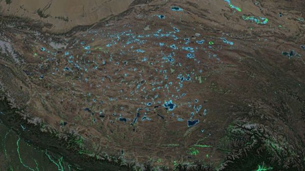
New lakes – seen as blue areas – are appearing on the Tibetan Plateau (Image copyright DELTARES)
In the absence of early warnings from Tibet, water-related disasters can cause human and property losses downstream in Bhutan, Nepal, India and potentially Bangladesh.
Flooding and loss
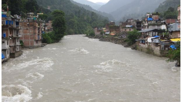
One recent event took place in July when buildings in Nepalese towns bordering Tibet were swept away by a sudden flood.Authorities in Nepal say it was the result of landslides in Tibet that dammed the Bhotekoshi river.
See: Hazards in the high mountains – part 1 of a special Koshi series
This is one of several rivers that run through Nepal which originate in Tibet.
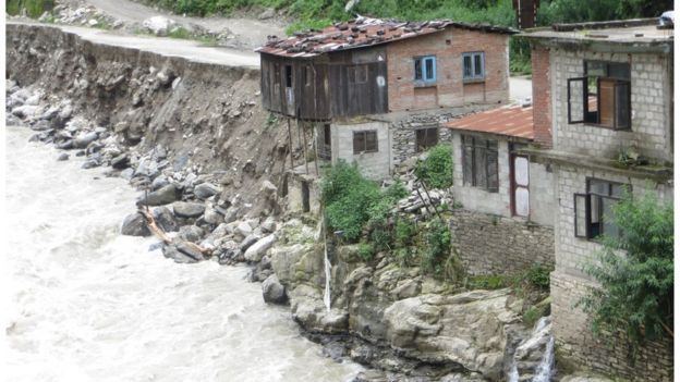
Most houses in Liping, the main town bordering Tibet, have either been swept away by floodwaters or brought down because of soil erosion caused by the floods.
The main part of Barabise town managed to withstand the monsoon floods but it suffered badly in last year’s earthquake
This was one of the most affected areas during last year’s earthquake.
“That is where my house used to stand and now all you see is a cliff overlooking the river,” said Nimji Sherpa, a shopkeeper.
“That night I received a call from my relative upstream that a flood was hurtling towards us. I dragged my old husband to higher land.”
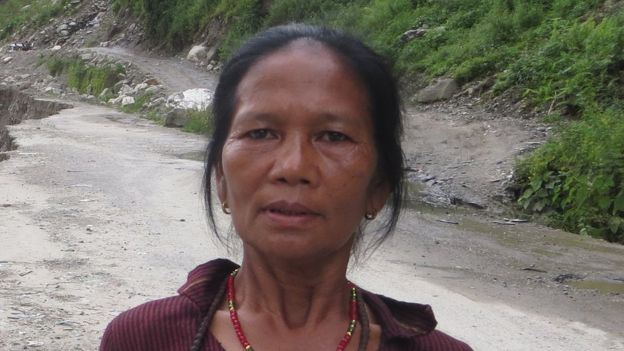
Nimji Sherpa is rebuilding her life for a third time
Further up, a stretch of the Arniko highway, that links Nepal to Tibet, is gone which has disrupted traffic.
“The authorities have told us to move 100 metres higher at night to sleep because we don’t know what is coming our way,” said Nimji Sherpa.
“How long can we live like this?”
Nimji Sherpa’s home used to be here but was swept away in the July flash floods
“We were lucky that we could save people because of our own early warning system but timely information from the Tibet side could have helped us save properties as well,” said Gokarna Dawadi, chief government official in the district, who recently left this role.
“We have approached the Chinese side a number of times to discuss this issue as we fear future disasters but it has not moved anywhere.”
In the past 80 years, scientists have recorded 10 occasions when glacial lakes burst out in Tibet and the flood waters reached Nepal.
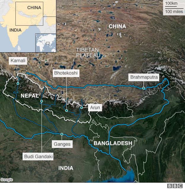
Many tributaries of the Ganges flow through Nepal so it’s a vital early warning state for flooding
“So far we have no communication between China and Nepal regarding the early flood warning system,” said Rishi Raj Sharma, director general of Nepal’s department of hydrology and meteorology.
“There has been some initial dialogue with the Chinese meteorology department but we need to raise this more seriously through our foreign ministry.”
Water everywhere
Residents of the Nepali towns bordering Tibet are having sleepless nights but settlements far away from the Tibetan territory are also at risk.The Bhotekoshi river is a tributary of the Kosi which flows down from Nepal into India to meet the Ganges.
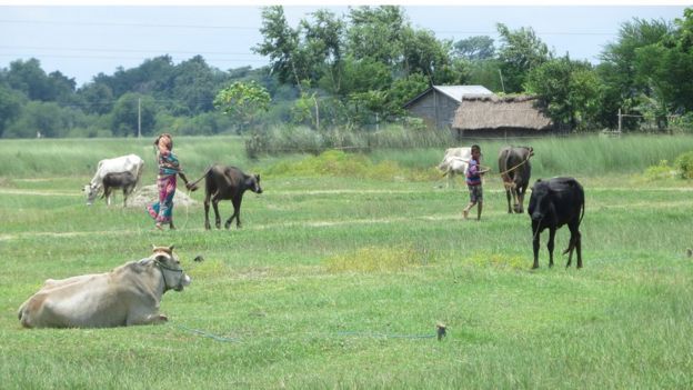
A rich and verdant land near the Kosi river
The Kosi, known as the sorrow of Bihar flooded in 2008, displacing tens of thousands of people in Nepal and India.
A local water expert Dev Narayan Yadav said fears of future floods were not unfounded.
“Our people here know how the bursting of glacial lakes in Tibet have flooded rivers in western Nepal and also in the Brahmaputra basin of India,” Mr Yadav explained.
“And because the Kosi disaster of 2008 is quite fresh in their memory, they are really wary of what might be happening upstream.”
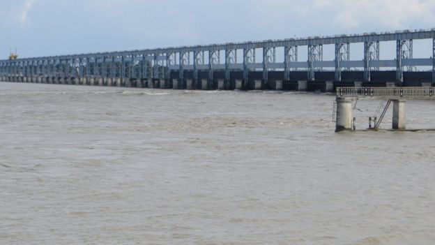
The Kosi barrage is more than 50 years old and people fear it’s no longer fit for purpose
It was built in 1962 and there are concerns it is no longer fit for purpose. The Indian government is planning to build a major dam upstream in Nepal.
“Big structures like these make us more scared because they will multiply the disaster and we will suffer,” said Mr Yadav
Indian attention
The Central Water Commission of India is tasked with planning and building the new dam.Officials say they have concerns about flooding from Tibet too but they’re focused on the dams China is building on Tibetan rivers.
“If waters from them are released in a larger quantity, they may become floods and if we have no storage in the Indian portion, that may create havoc,” the commission’s chairman Ghanashyam Jha told the BBC.
“We have an arrangement for sharing flood information but all the desired information is not available.”
The water resource department of the Indian state of Arunachal Pradesh that shares a border with Tibet has stressed the proper networking of co-basins for flood warnings.
“The flash flood of Pasighat during 11 May 2000 is an example in which the loss of lives and properties could have been minimised had there been proper networking and sharing of information to the downstream county,” it says on its website.
The Chinese authorities in Beijing did not respond to our questions.
Officials in Tibet, however, said flood information was being shared with India and Bangladesh.
They said they would only do the same with Nepal if they received instructions from the Chinese ministry of water resources.
The United Nations hopes all countries in the region can work together
“I think there should be cross-boundary cooperation between countries in the region and unless it happens we cannot control floods,” says Vijay Singh, a senior official the United Nations Development Programme Nepal office, who has worked on flood management in the country for years.
“We are creating a platform so that governments of Nepal and China can come together and realise the importance of information exchange between the two but it will take some time.”
https://www.thethirdpole.net/2016/09/15/india-and-nepal-concern-over-tibet-flood-advice-gap/
No comments :
Post a Comment