Friday, December 30, 2016

No proven tie between quake, 
injection wells ?


State oil and gas regulators are in monitoring mode following a minor Christmas Day earthquake west of New Castle, but have found no obvious connection between the quake and wastewater injection wells in the area.
Stuart Ellsworth, engineering manager for the agency, says it also has done an evaluation following a larger, magnitude-4 earthquake that happened Dec. 23 in northern New Mexico, just across the border from Trinidad, Colo. But it found that the few Colorado injection wells near that epicenter are relatively inactive, either being shut in or having fluids injected at a low rate.
The quake around 11:15 p.m. Christmas night was a magnitude 2.9 with an epicenter just south of the Colorado River. On Oct. 23 another, an even smaller quake of a magnitude 2.1 occurred almost immediately north of the Dec. 25 epicenter, just across the river and Interstate 70.
Ellsworth said four companies are operating injection wells within about 6 miles of the site of the Christmas Day quake, mostly to the southwest. All are injecting wastewater at low volumes and within specified pressures, he said. Higher injection volume rates and pressures are considered factors that could contribute to earthquakes.
Scientists and Oklahoma’s state government have determined there’s an apparent correlation between oil and gas wastewater wells and a sharp increase in earthquakes in that state. And an injection well in the Greeley area was linked a few years ago to a 3.2-magnitude quake and smaller subsequent ones.
Ellsworth said Colorado has about 350 wastewater disposal wells, compared to about 3,000 in Oklahoma. Wells in Oklahoma are undergoing injection rates of about 30,000 to 60,000 barrels of water a day, and the Greeley well had an injection rate of 10,000 barrels a day. Ellsworth said most wells in Colorado see injection rates of about 1,000 barrels a day. He said rock formations can’t absorb water being injected into them at too fast of a rate, and the science suggests against exceeding 10,000 barrels a day.
The COGCC has instituted a system for responding to earthquakes in areas where there are injection wells, with criteria for moderating or suspending operations in the case of higher-magnitude quakes. The system calls for monitoring an area in the case of an earthquake of magnitude 2.5 or higher, and so the agency is monitoring the area of the Christmas quake, Ellsworth said.
Ellsworth said the COGCC hasn’t requested any injection-operation changes by companies in the case of either the Garfield County or New Mexico border quakes.
Don Blakeman, a geophysicist and earthquake analyst with the U.S. Geological Survey, noted that earthquakes aren’t uncommon in Colorado.
“We see them every once in a while. They’re not unusual at all,” Blakeman said.
Ellsworth said there were two quakes in that same area west of New Castle back in the 1990s. That was before there was much drilling and injection well activity in that area. He said there haven’t been a lot of earthquakes in western Colorado’s Piceance Basin despite it being peppered with injection wells, and there’s never been a correlation between injection wells and earthquakes in the basin.
Decades ago in the Rangely area, federal researchers affirmed the ability to inject fluids to the point of causing seismic activity by doing just that, Ellsworth said.
While some researchers have suggested a link between high-rate injection wells and earthquakes in the Trinidad area, Ellsworth said the COGCC has never been able to make a correlation between injection activities and quakes there. Part of the problem in trying to draw such conclusions in that area is that it has a long history of natural-occurring earthquakes.

http://www.gjsentinel.com/news/articles/agency-no-proven-tie-between-quake-8232injection-w
Read more..

Thursday, December 29, 2016

Injection well opponents protest anniversary of Youngstown earthquake

YOUNGSTOWN, Ohio -
New Year's Eve marks the 5 year anniversary of the 4.0 magnitude earthquake that was linked to a fracking waste injection well in Youngstown. 
Thursday afternoon, supporters of Frackfree America held a prayer vigil to look back on the 2011 Earthquake but also to look forward on possible injection wells reopening that are used to dispose of oil and gas drilling waste. 
Frackfree America National Coalition Co-Founder, Jane Spies said, “We don't want that one to open. We don't want any of them to open seriously because its just not a safe way to get rid of waste.”
There is one injection well in Coitsville and another in the Weathersfield that may re-open.
“They seem to want to put it here in our area and we don't want it here because we don't think its safe. We've already had numerous earthquakes”, said Spies. 
Frackfree America Supporters have their concerns about possible re-openings of injection wells but the Ohio Department of Natural Resources Oil and Gas Division says they have made improvements over the last five years to prevent man made earthquakes.
According to ODNR there are currently 17 active injection wells in Trumbull County and 5 in Mahoning County that are being monitored by real time seismic activity monitors. 

ODNR Oil and Gas Division Spokesperson said, “If a monitor detects an event we can be notified via our system in a matter of minutes. So with that data and better technology we are then able to make a regulatory decision then in order to shut down an injection well.”
In addition to the 7 Trumbull County and 8 Mahoning county seismic monitors ODNR passed comprehensive regulations that cap the maximum allowable injection pressure at each well, but Frackfree America still has concerns. 
Spies said, “When they say they are going to monitor this and regulate this you can't regulate earthquakes you just can't and it's too big of a risk to public health and safety.”

http://www.wfmj.com/story/34149850/injection-well-opponents-protest-anniversary-of-youngstown-earthquake
Read more..

Thursday, December 22, 2016

Waterfall not flowing at Birchville Dam after earthquake inspection


 The Birchville Dam waterfall is no longer working after engineers lowered the water level.
After the November 14 Kaikoura earthquake, Greater Wellington Regional Council and specialist engineers at Dam Safety Intelligence Ltd inspected the dam as part of its post-earthquake routine.
An earlier survey had shown a surprisingly high amount of sediment so, despite the dam receiving no earthquake damage, engineers reactivated an intake pipeline to lower the water level in case a subsequent earthquake caused a breach.
"The waterfall has been affected but it is better to err on the side of public safety and, in fact, return the dam to its normal operating mode," council parks manager Amanda Cox said.
The water level would remain low for the foreseeable future.
In January council want to reopen another valve, the scour valve, to provide double insurance against water build up. "The valve will need to be reactivated to ensure we have two means of de-watering the dam."
Geotechnical engineers had completed a survey and the council expected their report in January. "There are no indications at this stage of any specific geotechnical site works being required."
Cox said the inspection was routine and entirely precautionary after any unusual events, such as the earthquake and flooding in November.
The dam was built in the 1930s and decommissioned following the opening of the Kaitoke water scheme in the 1950s. It is part of a popular walking track.

http://www.stuff.co.nz/national/nz-earthquake/87642735/waterfall-not-flowing-at-birchville-dam-after-earthquake-inspection
Read more..

It's Not Just Fracking: New Database of Human-Induced Quakes


In the largest compilation of anthropogenically induced earthquakes, causes range from building water reservoirs to mining.

How many earthquakes have human processes induced? Probably many more than we think, scientists indicated last week at American Geophysical Union’s Fall Meeting in San Francisco, Calif.
Just in the United States, the number of earthquakes per year in the center of the country has jumped dramatically since the early 2000s. According to the U.S. Geological Survey (USGS), each year between 1973 and 2008, the central United States experienced about 21 earthquakes of magnitude 3 or higher. This number grew to almost 100 per year between 2009 and 2013. In 2014 alone, the region experienced more than 400 earthquakes.
In the past few years, scientists have begun to better understand the relationship between industrial processes and “induced” earthquakes. Recent media attention has zeroed in on fracking and wastewater injection, but earthquakes are also induced by the load of water impounded behind a dam, mining processes, and extracting groundwater for irrigation, among other causes.
After repeated small quakes struck areas around an oil field in the Netherlands, the Dutch oil and gas exploration company NAM commissioned a study by earthquake experts to better understand human-induced earthquakes. The team, led by Gillian Foulger, a geologist at Durham University in the United Kingdom, ended up compiling the most complete database of occurrences to date. The team also found that induced earthquakes are “tremendously underreported,” Foulger said. She presented her team’s findings on Tuesday, 13 December.

Hunting for Quakes

Foulger and her colleagues spent a year digging through scientific literature, industry literature, newspaper reports, and accounts from colleagues to create the database of as many previously reported induced earthquakes as they could find. The database, which stretches back through the early 19th century, currently lists 715 earthquake sequences, each consisting of as many as several hundred quakes.
The catalog divides the causes of induced earthquakes into four general triggers: surface operations (such as quarrying, building structures, and impounding water reservoirs), injecting material into the subsurface (such as wastewater disposal in fracking), removing material from the subsurface (such as mining or pumping water for irrigation), and explosions from underground nuclear tests.

Mining-Induced Quakes Dominate

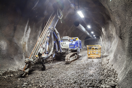
Processes like mining and drilling tunnels, which displace material from the subsurface, can induce earthquakes.
Processes like mining and drilling tunnels, which displace material from the subsurface, can induce earthquakes. Credit: iStock.com/aeduard
When the researchers looked at the data, one thing was clear: Out of the 715 cases of induced earthquake sequences, “mining by far dominated the picture,” Foulger said, with about one third of the earthquake sequences tied to mining processes. In fact, “British mine quakes account for about 50% of all earthquakes in Britain,” she noted.
Mining falls under the category “removing material from the subsurface.” Imagine gradually removing support beams and walls from a tall building, Foulger said—at some point, the building will collapse.
In 2007, for example, more than 100 mines in China reported seismic events larger than magnitude 4, Foulger said. In 1989, an induced magnitude 5 quake in Germany collapsed the surface over 5 square kilometers of a potash mine, killing three.
Not all the mining-induced quakes are so large, however. The majority of the mining quakes in the database range between magnitudes 2 and 4, according to the report.

Earthquake Sources in Groundwater Removal

Another example from the “removing material” column stems from Spain, Foulger said. In 2011, a magnitude 5.1 earthquake razed a small town called Lorca and killed 10 people. Research following the earthquake tied the event to the decades-long removal of water from the ground for irrigation, which drastically lowered the water table. This led to ground subsidence and resulted in the earthquake.
In fact, a 2014 paper in Nature found that the increase in small earthquakes recorded in California’s San Joaquin Valley could be tied to underground water removal. More than 100 cubic kilometers of water have been removed from the ground in the region over the last 150 years, mostly for irrigation purposes. “The removal of any mass from under the ground is going to create voids, and essentially the earth is going to collapse,” Foulger said. “There’s just so much material you can remove from the earth before it has to subside.” And sometimes that subsidence results in an earthquake, she continued.

Dam-Induced Quakes

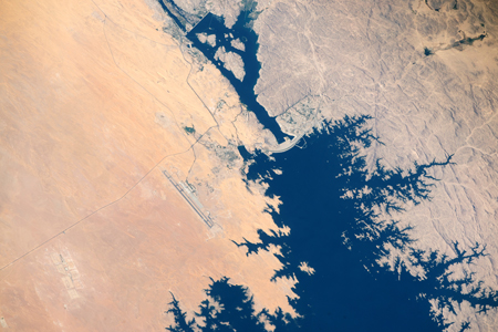
Lake Nasser
A view of Lake Nasser (top body of water), with north in the top left, captured by the International Space Station in April 2015. The lake, which holds 132 cubic kilometers of water, is impounded by the Aswan High Dam (curved central structure). The load from water reservoirs such as this can induce earthquakes by lubricating existing faults underneath it. Credit: NASA/ISS Crew
After mining, the next most common source of induced earthquakes, making up about 20%, is water reservoirs, Foulger said. Huge masses of water piling up on Earth’s surface affect the hydrology of the earth below in ways that can increase stress on faults. “If water is forced into fault zones, it reduces the confining stress and squeezes the fault open a little bit. It’s lubricating the fault,” she said.
A notable example is the Koyna Dam in India, which impounds about 3 cubic kilometers of water. There, a magnitude 5 earthquake occurs about every 5 years, according to the researchers’ report.
Other examples in the report include Egypt’s Aswan High Dam, which impounds about 132 cubic kilometers of water and has induced earthquakes up to magnitude 5.7. Also, in 2007, more than 7000 earthquakes were recorded over a 2-month period in Algeria as water was pumped from one reservoir into another.

Database for All

Unfortunately, induced earthquakes are likely underreported, Foulger noted, because documented earthquake sequences tend to come from places where humans felt them. Some projects, such as offshore oil and gas extraction, may be far from people, where earthquakes aren’t felt and thus aren’t recorded, she explained.
A corollary of this is that as populations move and grow, risk increases. For example, 15 years ago, “the residents of Oklahoma would not have suffered from the quakes” because, at that time, fewer people lived near areas where ongoing industrial processes induced quakes, Foulger explained. In the spring, Foulger and her colleagues will launch a website, InducedEarthquakes.org, which will allow anyone to report induced earthquakes. She hopes that by crowdsourcing for more information, researchers will be able to use the database to further catalog induced earthquakes and thus better understand them.
One caveat, Foulger also noted, is that the current list includes not only confirmed induced quakes but also earthquakes that scientists don’t necessarily agree were induced.
This could potentially cause problems, noted Susan Hough, a seismologist at the USGS’s Earthquake Science Center in Pasadena, Calif., who wasn’t involved with the research. “There will be a danger of people taking the catalog as gospel, not appreciating the fact that some associations remain controversial,” she said.
However, it’s a “worthy effort to try to compile a catalog,” Hough continued. “It will be useful to test hypotheses about induced earthquakes and, fundamentally, to highlight the scale and scope of the problem.”

Minimizing Risk

Despite the fears surrounding induced earthquakes, however, Foulger stressed that concerned parties should work with industry leaders to manage risk rather than attempt to cease industrial activities altogether. Think of it like building a road, she explained. The future road may be a source of car accidents, but “people don’t prevent industrial activity because new roads have to be built. These earthquakes are the same—a potentially dangerous side effect of industrial activity that needs to be managed.”
—JoAnna Wendel (@JoAnnaScience), Staff Writer

Citation: Wendel, J. (2016), It’s not just fracking: New database of human-induced quakes, Eos, 97, doi:10.1029/2016EO065433. Published on 22 December 2016.
https://eos.org/articles/its-not-just-fracking-new-database-of-human-induced-quakes
Read more..

Thursday, December 8, 2016

Oklahoma 'almost certain' for another damaging earthquake; risks to be elevated for next decade but on decline

Oklahoma is “almost certain” to have at least one damaging earthquake in the next five years, with heightened risks of a large quake probable to endure for a decade even with declining the frequency, according to an author of research modeling the state’s man-made quakes.
Stanford geophysicist Cornelius Langenbruch points out his and a colleague’s recent study also further solidifies the "clear relation" between wastewater injection volumes and earthquake rates.
For example, the study highlights that the seismic energy released in the past eight years of record saltwater disposal volumes from oil and natural gas production is equivalent to "more than 1,900 years of naturally occurring energy.”
In another finding, the number of quakes outside two large areas of interest that feature the high disposal volumes is "generally consistent" with "tectonic background activity" Oklahoma historically experiences. Combined, the study says, those two areas of interest “contain almost all recent earthquakes.”
The peer-reviewed study published online recently in Science Advances offers welcome news: The state's seismicity should return to its typical background levels with the regulatory cap on injection volumes. But effects from years of putting so much saltwater into deep disposal wells will be felt by Oklahomans for several more years.
Langenbruch, who authored the research paper with fellow Stanford geophysicist Mark Zoback, spoke with the Tulsa World by telephone. He said elevated risks will remain in the earthquake zone in the next five to 10 years for a quake capable of inflicting damage to buildings, not ruling out the possibility for multiple large temblors.
The state's 180-day moving average of magnitude-2.8 or greater quakes peaked at approximately 4.5 per day in summer 2015, tailing off to about 2.3 a day this fall.
"It is very important to note that the earthquake rates are not low, they are really high compared to what has been observed prior to 2009," Langenbruch said. "So it means that the probability of potentially damaging earthquakes in the next five to 10 years is still high compared to what has been observed in the past."
Notably, Langenbruch said the study's parameters allow for the prediction or quantification of earthquake probabilities based on planned injection volumes. Or in other words, the study offers a model to regulate injection levels based on whatever is deemed to be an acceptable level of induced-seismicity risk.
The model predicts a 37 percent chance in 2017 for Oklahoma to experience a quake that exceeds magnitude-5.0. The Pawnee area is at a much higher risk after a state-record 5.8 in September, with a 58 percent probability to exceed a 5.0 and 7 percent chance to surpass a 5.8.
Regulatory cap 'should be enough'
Two Oklahoma Corporation Commission directives in the spring imposed a cap on injection volumes in a 15,000-square-mile region of interest at 40 percent below 2014’s output. A combination of the depressed energy market and the regulatory restrictions have achieved that reduction.
The mandated disposal rate in the region of interest after May “remains almost twice as high” as 2009 levels, which the study pegged as the start of the sequence of induced seismicity. But because those volumes now are spread throughout a region twice as large as in 2009, “the average injection volume per unit area” is similar to that of 2009.
“On a large scale, we think this 40 percent reduction should be enough,” Langenbruch said. “But on a local scale, things might look different.”
He explained that the pressure increase in the underground from years of disposing vast saltwater volumes into deep wells is slowing but remains high. On a local level, fluid injection especially close to a critically stressed and optimally aligned fault might present a greater risk than the quake zone as a whole.
For that reason, Langenbruch said, it’s key to gather better data on underground pressures to begin effectively addressing seismicity from a localized standpoint — perhaps even by individual well. The state’s crystalline basement is laced with pre-existing faults poised to slip when pressures generated by the wastewater touch them. The majority are small but some are quite large, he said, and many are unknown or haven’t been mapped.
“Maybe these faults can be mapped, but right now we’re not sure,” Langenbruch said. “These faults could be everywhere.”
A prime example is demonstrated by the record Pawnee quake on Sept. 3. The magnitude-5.8’s aftershocks revealed an unknown fault and prompted amended disposal well restrictions in the area.
Langenbruch said he believes the pressure is still spreading outward. However, the pressure far away from the disposal wells is “very low,” meaning it’s not as likely to trigger fault slips, he said.
“I don’t think (the earthquake zone) will get significantly bigger unless there are other places in Oklahoma where the injection rates are now significantly increased,” Langenbruch said.
The study notes that before 2009 the state averaged about one magnitude-3.0 or greater quake each year. In 2015 there were about 900 of those size quakes — by far Oklahoma's record.
The authors offered a caveat that forecasting the earthquake hazard is difficult, and their study isn't a "final and reliable seismic hazard model" for the state. But the model yields promise as a scientifically valid tool to manage man-made quakes.
“The good thing is that I think finally everybody understands that seismic hazards have to be mitigated in Oklahoma, and everyone is working together,” Langenbruch said.

http://www.tulsaworld.com/earthquakes/oklahoma-almost-certain-for-another-damaging-earthquake-risks-to-be/article_74cbbc8c-0ba1-510c-8c67-53ac18d3b2b3.html
Read more..

Tuesday, November 1, 2016

Big Quakes in California Possibly Triggered by Oil Production, Study Says

The Western States Petroleum Association, an industry trade group, says there is no evidence of a link between present-day oil activity in California and earthquakes. Here, pumpjacks at work in Bakersfield, Calif., in January 2015. Photo: Jae C. Hong/Associated Press


Some of the biggest earthquakes that rocked Southern California during the early 20th century were possibly triggered by oil production, according to a new study published Monday.
The U.S. Geological Survey study, based on historic oil-drilling records kept by the state as well as quake archives, comes amid public and scientific scrutiny of the potential connection between industrial activity and earthquakes.
Earthquakes tied to the disposal of wastewater from oil and gas production by injecting it into the ground have rattled Oklahoma, Texas and other oil-producing states in the central part of the country.
Between 1920 and 1933, four earthquakes measuring more than magnitude 5 may have been induced by activities related to oil production, according to the study published in the Bulletin of the Seismological Society of America.
One of those quakes, the 6.4-magnitude Long Beach quake of 1933, killed 115 people.
Scientists say records show drilling took place nearby and shortly before each event.
“A common theme we found was when they drilled down to rock,” said Susan Hough, a USGS geophysicist who co-authored the study.
The USGS released maps earlier this year that for the first time show the potential risk of man-made as well as naturally occurring earthquakes, with some parts of Texas and Oklahoma now at the same danger of temblors as California.
Unlike those quakes, which the USGS has said may be caused by wastewater disposal wells, Ms. Hough said the Southern California earthquakes could have resulted from an imbalance in subterranean pressure that resulted after oil was removed from near fault lines.
She said separate studies have shown no link between drilling and earthquakes in the Los Angeles area in the second half of the century, when an improved technique was used to extract oil.
The Western States Petroleum Association, an industry trade group in Sacramento, Calif., said there is no evidence of a link between present-day oil activity in California and earthquakes.
“A multitude of recent scientific studies suggest there is no correlation between the production of petroleum in California and seismic activity,” said Catherine Reheis-Boyd, president of the association.
“Modern industry innovations, along with increased reporting and monitoring, have combined to ensure energy production in California remains safe and efficient,” she said.
The latest findings could alter the way seismologists  have viewed earthquake activity in one of the nation’s most active seismic areas.
By removing those early 20th century quakes as naturally induced, “it does call into question what the rate of natural earthquakes in the L.A. Basin really is,” Ms. Hough said. “Maybe the L.A. Basin as a geological unit is more seismically stable than we’ve estimated.”
Write to Jim Carlton at jim.carlton@wsj.com

http://www.wsj.com/articles/big-quakes-in-california-possibly-triggered-by-oil-production-study-says-1477966625 
Read more..

Wednesday, October 26, 2016

Wastewater Disposal Likely Induced February 2016 Magnitude 5.1 Oklahoma Earthquake

Distant wastewater disposal wells likely induced the third largest earthquake in recent Oklahoma record, the Feb. 13, 2016, magnitude 5.1 event roughly 32 kilometers northwest of Fairview, Oklahoma. These findings from the U.S. Geological Survey are available in the online edition of Geophysical Research Letters.
At the time, the Fairview earthquake was the largest event in the central and eastern United States since a 2011 magnitude 5.7 struck Prague, Oklahoma. The 5.1 magnitude event occurred southwest of a group of high-rate wastewater disposal wells greater than 12 kilometers away. In the region surrounding the Fairview earthquake sequence, the volume of fluid injected increased 7-fold over three years.
”The fact that seismicity is rather limited near the high-rate wells while the Fairview sequence occurred at a relatively larger distance from these wells, shows us the critical role preexisting, though possibly unknown, fault structures play in inducing large events,” said Dr. William Yeck, a USGS scientist and lead author of the study. “The rapid deployment of seismic stations by the USGS allowed us to precisely locate the aftershock sequence. High-quality data sets such as these are critical when trying to understand the shaking produced by these events and therefore are an important basis for earthquake hazard modeling.”
Earthquakes in this area primarily occur at depths of 6 to 9 kilometers, roughly 3.5 to 6.5 kilometers below the Arbuckle Group in which wastewater is typically injected.
On September 3, 2016, Oklahoma experienced the largest earthquake since 2011 when a magnitude 5.8 earthquake occurred near Pawnee, Oklahoma.
While the relationship between the Pawnee earthquake and wastewater injection is still under investigation, studies such as this further scientific understanding of the complex relationship between wastewater disposal and earthquakes.
Read more..

Saturday, October 15, 2016

It's Official: Injection of Fracking Wastewater Caused Kansas’ Biggest Earthquake

The largest earthquake ever recorded in Kansas—a 4.9 magnitude temblor that struck northeast of Milan on Nov. 12, 2014—has been officially linked to wastewater injection into deep underground wells, according to new research from the U.S. Geological Survey (USGS).

The epicenter of that extremely rare earthquake struck near a known fracking operation.
The Wichita Eagle noted from the study that this man-made quake, which hit 40 miles southwest of Wichita and felt as far away as Memphis, likely came from just one or two nearby wells. The publication ominously noted that, "one of those two wells, operated by SandRidge Energy, is still injecting water at the same level as when the earthquake occurred two years ago."
The USGS scientists believe that the 4.9-magnitude earthquake was triggered by wastewater injection for the following reasons:
  • There had not previously been similar earthquakes in the area.
  • There were waste-water injection wells nearby.
  • The earthquake activity started after the amount of water injected in the wells increased.
  • There's a piece of earth that could be activated by changes in pressure.
Kansas has had a long history with fracking. In fact, the first well ever fracked in the United States happened in 1947 in the Sunflower state. The process is now used for nearly all of the 5,000 conventional wells drilled in Kansas every year.
But just like Oklahoma, Kansas is seeing an alarming uptick of "induced" earthquakes connected to the underground disposal of wastewater from the fracking process. Kansas is a region previously devoid of significant seismic activity, however, the number of earthquakes in the state jumped from only four in 2013 to 817 in 2014, The Washington Post reported.
According to an August report from The Wichita Eagle, Kansas has seen fewer and weaker earthquakes following the Kansas Corporation Commission's recommendations to reduce underground injection of oilfield wastewater.
Incidentally, the Milan quake and the record-breaking 5.8 earthquake that struck Pawnee, Oklahoma last month occurred on faults that scientists did not previously know existed.
"If the well is in the right place next to a fault and the fault is oriented the right way, a little change in stress could cause (an earthquake) to occur," USGS geologist George Choy, the study's lead author, told The Wichita Eagle.
The study will be published in Seismological Research Letters next month.
"The source parameters and behavior of the Milan earthquake and foreshock–aftershock sequence are similar to characteristics of other earthquakes induced by wastewater injection into permeable formations overlying crystalline basement," the study abstract states.
SandRidge Energy is the largest oil producer in Kansas and the largest disposer of wastewater in Oklahoma. In January, the Oklahoma-based company refused to abide by the Oklahoma Corporation Commission's recommendations to shut down or decrease wastewater injection in order to prevent more earthquakes. The company agreed to shut down wells and reduce wastewater volumes months later.

http://www.ecowatch.com/fracking-wastewater-kansas-earthquake-2045480679.html
Read more..

Saturday, September 3, 2016

Strongest Earthquake Ever Recorded In Oklahoma Felt In Multiple States Saturday Morning, Blamed On Fracking Wastewater

Reports have just surfaced of a 5.6 magnitude earthquake which struck approximately 55 miles northwest of Tulsa. According to the Dallas News, the quake was felt by people more than 750 miles from the epicenter.
The 5.6 magnitude earthquake struck just northwest of Pawnee and was felt across Oklahoma, Kansas, Texas, Nebraska, Arkansas, Missouri, and Iowa. Many on social media reported being awakened by the quake, which struck at about 7:02 EDT.
The USGS confirmed on their website and on social media that the 5.6 magnitude quake had struck, originating at a depth of 6.6 km.
Oklahoma has experienced a number of earthquakes in recent years, but they are typically under 4.0 magnitude. Today’s earthquake is either the strongest, or tied for the strongest, that the state has ever experienced, depending on how one measures. According to Tulsa World, the previous record was set by another 5.6 magnitude quake in Prague, Lincoln County.
Another strong earthquake, of 5.1 magnitude, struck in Fairview, Major County, in February this year, after a 4.8 magnitude quake in the same location in January.
Today’s earthquake was strong enough to be felt across much of the southern United States, and reports are still coming in.
This was the first strong earthquake to strike Pawnee County, and as such, may be cause for some concern, potentially indicating a new fault line opening, or a previous fault system, such as those running through Lincoln County, expanding.
The USGS has currently assigned a “green” status to the quake for both economic damage and loss of life; the damage from the quake, in spite of its strength, is expected to be minimal.
According to CNN, Dede Pershall, the Pawnee police and fire dispatcher, said that a number of damage reports were coming in from people near the earthquake’s epicenter.
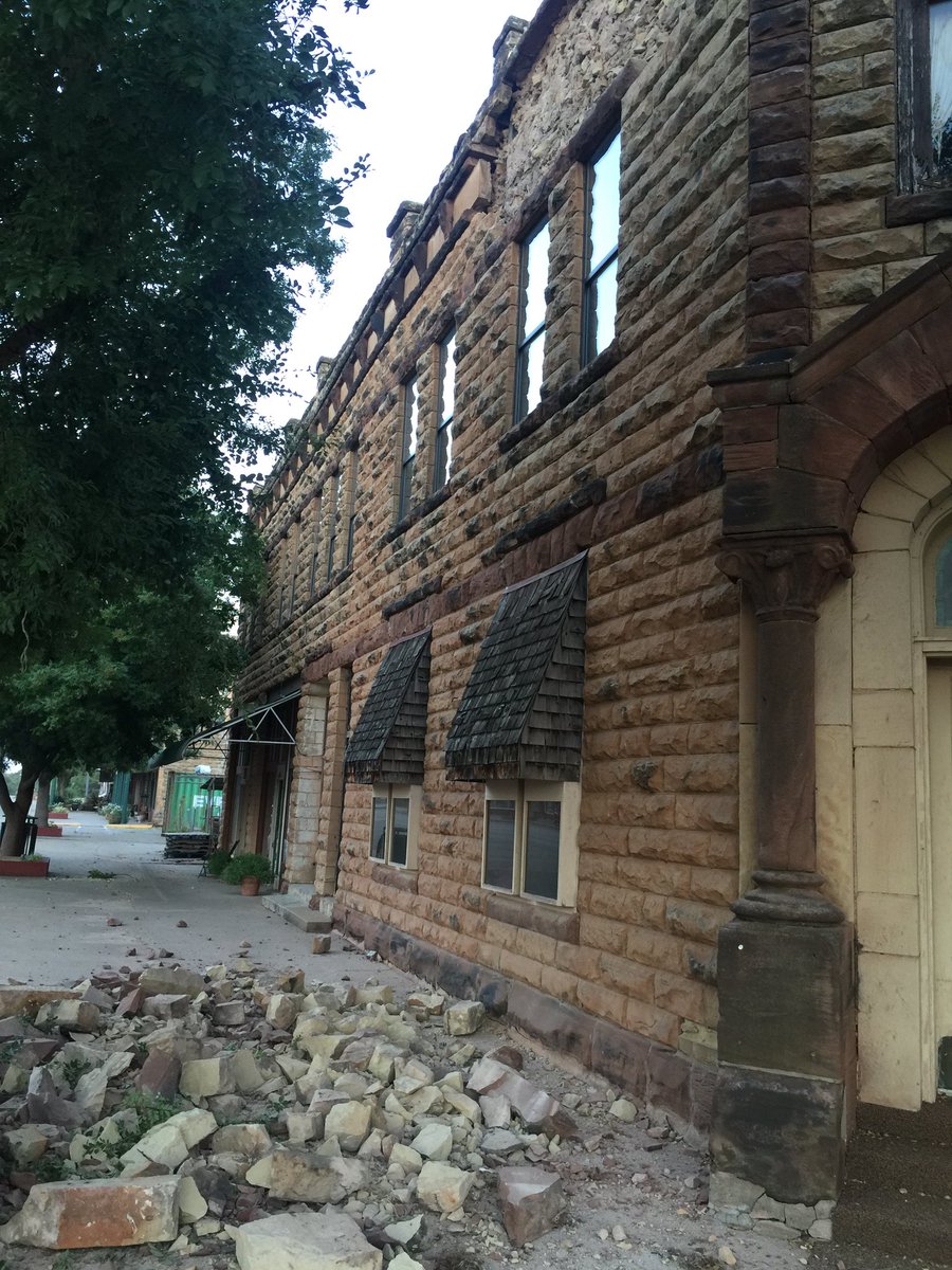
“We are getting lots of of reports of buildings with bricks that came off and broken windows.”
Keli Cain, spokesperson for the Oklahoma Department of Emergency Management, confirmed that this was the biggest quake to hit Oklahoma since 2011.
According to the Associated Press, the increase in high-magnitude earthquakes in Oklahoma has been linked to fracking wastewater disposal – wastewater created in the extraction process for oil and natural gas in the state. Regulators have asked the oil and gas industry to reduce their wastewater emissions in response to the increased earthquake frequency; some areas of Oklahoma are now as prone to high-magnitude earthquakes as northern California – America’s most earthquake-prone region.
Parts of Oklahoma now have a 1 in 8 chance of a damaging earthquake in 2016.
Currently, no major damage or loss of life as a result of the quake have been reported, but reports are noting that the same spot saw a 3.2 magnitude earthquake earlier in the week, which went mostly unremarked, and that there is a danger of further quakes in the region.

More from Don Crowthers,
http://www.inquisitr.com/3478980/strongest-earthquake-ever-recorded-in-oklahoma-felt-in-multiple-states-saturday-morning-breaking/

EXTRA:
View image on Twitter
damage in Pawnee
 
Read more..

Tuesday, August 23, 2016

EPA: North Texas quakes likely tied to oil activity

Federal regulators believe "there is a significant possibility" that recent earthquakes in North Texas are linked to oil and gas activity, even if state regulators won't say so.
The U.S. Environmental Protection Agency made the connection in its annual evaluation of how the Texas Railroad Commission oversees thousands of injection and disposal wells that dot state oil fields — underground resting places for millions of gallons of toxic waste from fracking and other drilling activities.
"In light of findings from several researchers, its own analysis of some cases and the fact that earthquakes diminished in some areas following shut-in or reduced injection volume of targeted wells," the Aug. 15 report states, "EPA believes there is a significant possibility that North Texas earthquake activity is associated with disposal wells."
Scientists have known for decades that injecting fluid deep underground could trigger earthquakes, and a growing body of research has linked disposal wells to seismicity in Texas and other states, which has grown more frequent.
Jim Bradbury, a Fort Worth oil and gas lawyer who has closely followed the earthquake saga, said he could not recall the EPA explicitly tying Texas earthquakes to industry activity.
"It's a big deal they said that," he said.
Texas, home to thousands of such wells, is the third-most at-risk state for man-made earthquakes, according to the U.S. Geological Survey — behind only Oklahoma and Kansas.
Several Texas drilling regions have felt more earthquakes in recent years, most of them small. With one exception, that was the case with quakes that rattled parts of rural East Texas beginning in 2012. But temblors in the Dallas-Fort Worth area have drawn the most attention, particularly those that struck in the past two years.
The EPA report said quakes in North Texas raise concerns "because of the potential to impact public health and the environment, including underground sources of drinking water."
The shaking has created political challenges for the Texas Railroad Commission, which oversees the powerful oil and gas industry.
Since 2014, the agency has added a staff seismologist and approved regulations requiring disposal well operators to submit more geographical information. But the agency, which has conducted its own investigations, has not publicly tied any of the shaking to industry activity — even as regulators in other petroleum states acknowledge a connection. The Railroad Commission has pushed back against conclusions of some outside studies.
Responding to the EPA report Monday, the commission told The Texas Tribune it "takes the issue of induced seismicity very seriously and has in place some of the most stringent rules on disposal wells."
Since approving those 2014 rules, the commission has received 56 disposal well applications in historically seismic areas, spokeswoman Gaye McElwain said in an email. Of those, the agency has issued 28 permits with "special conditions" — those related to injection volumes and pressures, for instance. Eleven applications were withdrawn or returned, while three were protested and sent to hearings. "Ten permits were issued without special conditions, and four applications are pending," McElwain said.
In its assessment, the EPA "commended" the Railroad Commission for establishing new regulations on disposal wells and clarifying its authority to shut down certain operations it ties to earthquakes. But the federal agency recognized that its own findings about North Texas seismicity run counter to what the Railroad Commission has publicly stated.Earthquakes are generated by slipping faults, or fractures. Experts say that injecting fluids at high pressures can relieve pressure in some faults, causing them to slip. And "naturally fractured injection formations may transmit pressure buildup from injection for miles," the EPA assessment notes, highlighting one such formation in North Texas — the Ellenburger — which is a popular disposal zone.Luke Metzger, director of the advocacy group Environment Texas, suggested the EPA was simply "stating the obvious" about the cause of the quakes."EPA should insist the [Railroad Commission] accept the scientific evidence and take action to protect Texans from earthquakes," he said.But Bradbury, the North Texas attorney, found something more remarkable in the federal agency's message to the Railroad Commission — particularly because the EPA had previously said little publicly about quakes in Texas. "It is obvious to everyone that [the Railroad Commission]is intentionally avoiding the reality that the larger scientific community has embraced and is working on," Bradbury said in an email. "I think it reveals that EPA is troubled by that reality."In its report, the EPA recommended, "close monitoring of injection activity" going forward, coupled with "appropriate data analysis methods, in a coordinated effort to detect possible correspondence with seismic activity."Bradbury noted that the EPA has the power to revoke the commission's authority over disposal wells."It's the EPA's program, and they can cause the [commission] a lot of grief," he said.University of Texas at Austin researchers call it "plausible" that underground injections of oil and gas waste triggered a series of temblors that rattled Timpson residents in 2012.State lawmakers are considering a nearly $2.5 million plan to help answer a pressing question in some Texas communities: Why does the ground keep shaking?A peripatetic seismologist and son of McCamey has been hired to figure out whether oil and gas drilling is causing earthquakes in Texas. No matter what he says, some people will not believe him.After wrapping up a round of testing, Texas regulators say they have found no evidence that injecting oilfield waste into five disposal wells triggered the largest recorded earthquake in North Texas' history.After a contentious town hall meeting concerning the possible links between wastewater injection and a spate of North Texas earthquakes, locals say they cannot afford to wait forstate regulators to address the issue.

https://www.news-journal.com/news/2016/aug/22/epa-north-texas-quakes-likely-tied-to-oil-activity/
Read more..

Wednesday, August 17, 2016

Fracking, Earthquakes and Hydro Dams? Don’t Worry, We Have an Understanding.

By Ben Parfitt for the Canadian Centre for Policy Alternatives.
Efforts by BC Hydro to ban potentially destructive natural gas company fracking operations in the vicinity of its biggest dams fall well short of what an Alberta hydro provider has achieved, raising questions about why British Columbia isn’t doing more to protect public safety.
Documents obtained through a Freedom of Information (FOI) request by the Canadian Centre for Policy Alternatives show that BC Hydro officials have feared for years that fracking-induced earthquakes could damage its dams and reservoirs.
Senior dam safety officials with the public hydro utility even worried for a time that natural gas companies could drill and frack for gas directly below their Peace River dams, which would kill hundreds if not thousands of people should they fail.
“The Montney gas field has vertical stratification of subsurface [natural gas] rights, so there may actually be a number of different owners laying claim under our damsites,” BC Hydro’s director of dam safety, Stephen Rigbey said in an April 2012 email released in response to the FOI.

No Mandated Frack-free Zones Near Dams

Yet, after years of discussions with B.C.’s Oil and Gas Commission (OGC), which regulates oil and gas industry activities in the province, BC Hydro has obtained only modest commitments to prevent fracking near its two Peace River dams — the massive WAC Bennett dam, which impounds the world’s seventh-largest reservoir, and the smaller Peace Canyon dam downstream.
The restrictions, which BC Hydro’s director of dam safety Stephen Rigbey describes as “an understanding,” also apply to a third dam on the river, the controversial $9-billion Site C project, currently in pre-construction.
Both BC Hydro and the OGC say that the understanding is that “there will be no new tenures” issued to companies wishing to drill and frack for natural gas within five kilometres of BC Hydro’s dams. However, companies holding existing rights would not be prevented from doing so.
“If future activity related to the existing tenures is planned, we will work closely with the Oil and Gas Commission to put restrictions in place to effectively manage any risk,” Rigbey said in an email response to questions.
What those measures would be remains the subject of ongoing discussions. No restrictions are presently in place around any of the massive reservoirs impounded by BC Hydro’s Peace River dams or the lands that could one day surround the Site C reservoir.
In an email response to questions, the OGC said that at this point in time, the Ministry of Natural Gas Development “is not accepting any new requests for subsurface [natural gas] rights within 5 kilometres of the Site C construction area.”
The Commission went on to say that “there are no active hydraulic fracturing operations” within the five kilometres of BC Hydro’s Peace River dams but that there are “a small amount of existing subsurface rights issued within the 5 km buffer zone around Site C.”
“These were issued prior to the creation of the buffer. Any applications in that area, or elsewhere, go through a strict review process before permits are issued. The Commission is also talking with BC Hydro about any additional permit conditions that would be required to protect public safety and the environment in the area specifically, before construction occurs on Site C.”
The measures to date in B.C., fall well short of what Alberta hydro provider, TransAlta, has achieved. In interviews and correspondence with the company, TransAlta revealed that it has effectively shut down all fracking within five kilometres of one of its dams and also around the entire dam’s reservoir as well. And it has succeeded in imposing restrictions on potentially destructive fracking operations in a zone up to ten kilometres away from its damsite.
But, as is the case in B.C., there is nothing in writing to reassure members of the public — no regulation or government statement — banning natural gas companies from fracking near sensitive infrastructure such as hydro dams and reservoirs. Both provinces appear reluctant even to suggest that fracking is inappropriate in certain cases where public safety is concerned, perhaps fearing the precedent such an admission would represent.
“At this time there is no regulated/government mandated exclusion areas near critical infrastructure in Alberta,” says TransAlta’s chief media spokesperson, Stacey Hatcher. Rather, Hatcher says, an “agreement” has been reached to exclude some hydro dams and reservoirs from fracking zones.

Christy Clark's Conflicting Agendas

BC Hydro’s modest achievements to date come as the Christy Clark government pursues two at times conflicting agendas. On the one hand, the government vows to push its Site C hydro dam, the most expensive infrastructure project in B.C.’s history, “past the point of no return.” On the other, it continues to aggressively push for Malaysian state-owned Petronas to invest billions of dollars to build a Liquefied Natural Gas (LNG) processing plant near Prince Rupert and to tarnish all those who oppose the project. Should such a plant be built, natural gas drilling and fracking near the Peace River and its hydro facilities would significantly ramp up.
In an April 2012 email, Rigbey likened potential fracking in the Peace to “carpet bombing,” and added that much of the anticipated fracking in future years would occur across the “well-established” regional stress regime.
Even if no such plant materializes in B.C. — an increasing likelihood given the recent announcement that another LNG proponent, Shell, appears ready to scrap its bid to build one — an upswing in natural gas prices would almost certainly result in increased gas drilling and fracking operations, including on lands alongside the reservoir that would be created by the Site C dam, which would flood more than 100 kilometres of the Peace River and its tributaries.
Documents filed by BC Hydro with a panel that reviewed the project for the provincial and federal governments noted that, even in the absence of fracking, nearly 4,000 landslides are expected to dump debris into the reservoir as a result of the Site C dam being built. The 676-page report that discusses those landslide risks makes no mention of additional risks to the reservoir should earthquakes be triggered nearby.
Martyn Brown, a former chief of staff to Premier Clark’s predecessor, Gordon Campbell, says the province’s conflicting agendas underscore a troubling aspect of the government’s regulation of oil and gas industry operations near critical infrastructure. From the outset, Brown says, the OGC has both promoted and regulated oil and gas industry activities. Limiting where companies drill and frack is simply not part of the OGC’s mandate or culture.
Brown likens the OGC to the National Energy Board. “It has a dual role as a proponent of oil and gas development, but also its regulator. And I think there is a fundamental conflict with that,” Brown says. He adds that “political oversight” of the OGC is also problematic because two Cabinet ministers — Energy and Mines Minister, Bill Bennett, and Minister of Natural Gas Development, Rich Coleman — are effectively there to “promote oil and gas activity.”
Concerns for public health and safety should mean that when tensions between the province’s publicly owned hydro utility and the natural gas industry arise it falls to a neutral ministry to determine what activities will be allowed or disallowed near critically important public infrastructure like dams and reservoirs, Brown said.
“Clearly what you need now is an independent voice in cabinet, the Environment Minister, to make broad determinations in an independent way,” Brown said. “The promoter should not be the regulator of oil and gas activities.”

Fracking-induced Earthquakes Cause Alarm

Documents released in response to the FOI request show that in both Alberta and British Columbia hydro providers have become increasingly alarmed at natural gas company incursions onto lands near their dams. The concerns have escalated as distinct clusters of earthquakes in confined areas over short periods of time have occurred in lockstep with fracking operations.
In one email, Rigbey notes that there are “no regulations to stop” oil and gas companies “from injecting into a pre-existing fault” in the rock. In other words, there is a risk that induced fractures could be forced into geologically unstable areas triggering or setting the stage for earthquakes. While gas companies might not want to tap into such faults, Rigbey noted, “accidents can happen.”
In its public pronouncements, however, BC Hydro has been more muted in its concerns. In a 551-page report filed with the joint federal-provincial panel that reviewed the Site C project for example, BC Hydro devoted less than two pages to discussing “petroleum industry-related” earthquakes and it downplayed their threats.
“The Oil and Gas Commission is now establishing procedures and requirements for monitoring and reporting of induced seismicity,” BC Hydro reported to the panel in January 2013. “Each case of induced seismicity will be evaluated on the basis of its unique site-specific characteristics, but it is proposed that hydraulic fracturing would be suspended upon detection of an earthquake of magnitude M4 or larger. It should be noted that earthquakes less than about magnitude M5 do not release enough energy to cause damage to engineered structures.”
In response to written questions, the Oil and Gas Commission said that as a result of discussions with BC Hydro the province “has established a five kilometre buffer area around the WAC Bennett, Peace Canyon and Site C dams.”
Graham Currie, the OGC’s executive director of corporate affairs, added that the Site C dam location is squarely within the Montney Basin, which contains large quantities of shale gas. Gas from dense shale rock formations can only be coaxed from the earth by extensive use of fracking.
Gail Atkinson, an expert on induced earthquakes and a professor in earth sciences at the University of Western Ontario (UWO), says induced earthquakes can be hazardous because they occur much closer to the earth’s surface than do natural earthquakes. If such events happen near dams or other surface structures, the ensuing shaking can be much worse than would be the case with a naturally occurring earthquake of the same magnitude.
The higher the number of fracking-induced earthquakes near dams, the greater the risk that one of them might be sufficiently strong enough to exceed what the dams are engineered to withstand.
“If the frequency of experiencing earthquakes near a dam increases, then the level of expected ground motions at the 1 per cent in 100 year likelihood level will increase,” Atkinson said. She warns that the risk will be greatest “in areas where the hazard was initially low because there is little natural seismicity.”
Atkinson added that even earthquakes of a “moderate” strength could damage dams or other structures if they are induced “at close distances” to such structures.
Such risks are not something that BC Hydro talks about publicly, however. In an on-line video on dam safety, for example, Rigbey talks about the threats to dams from naturally occurring earthquakes but never once even mentions fracking or the increasing number of tremors associated with it.

Alberta's TransAlta 'Concerned' About Fracking Earthquakes Near Dams

Atkinson’s work has clearly influenced TransAlta’s thinking. The company is one of three organizations that funds Atkinson’s fully endowed research chair on hazards associated with induced earthquakes at UWO. The other two are the National Sciences and Engineering Research Council and Nanometrics, a maker of seismic monitoring equipment. TransAlta also pays for some of its engineers and dam safety officials to be part of an ongoing multi-disciplinary research effort known as the Canadian Induced Seismicity Collaboration or CISC.
The CISC’s website notes that fracking-induced earthquakes are a “pressing problem” in Western Canada and in British Columbia and Alberta particularly. “There is a significant (though very small) possibility that triggered events could be large enough to cause significant damage,” the CISC’s scientists say.
According to Hatcher, TransAlta has secured agreement from natural gas companies operating in Alberta that they will adhere to a special “traffic light” system in a zone between five kilometres and 10 kilometres from its Brazeau dam and the shorelines of the dam’s 13-kilometre-long reservoir. “The traffic light system works in a similar manner to other traffic light systems for hydraulic fracturing, with a Green (proceed)/Yellow (pause and monitor) and Red (stop) protocol,” Hatcher said in written response to questions.
“TransAlta is concerned about the potential impact of fracking induced earthquakes and continues to work with the Alberta Energy Regulator (AER), Alberta Environment and the oil and gas operators to ensure that hydrocarbon development occurs in a safe manner that doesn’t create unnecessary risk to existing infrastructure,” Hatcher added.
In the much more sensitive zone immediately beside the dam and reservoir and extending out five kilometres, TransAlta has effectively shut down all fracking operators after filing a number of “statements of concern” with the AER, Alberta’s equivalent of the OGC.
Hatcher said that TransAlta could not release the documents and referred questions to the AER. The Canadian Centre for Policy Alternatives has filed a second Freedom of Information request to obtain copies.
Documents released by BC Hydro in response to the first FOI show that BC Hydro was prompted to call for frack-free buffer zones around its dams after learning what TransAlta had achieved in Alberta. BC Hydro’s Peace River dams are not only the biggest power sources in the province’s hydroelectric network (the Bennett dam furnishes one-quarter of the province’s hydroelectric power), but also in the region of the province with the richest natural gas reserves.

Special Consideration Given to Underground Gas Storage Reservoir

Only one other highly sensitive, yet little known, infrastructure project in B.C. is currently the subject of special operating guidelines as far as fracking is concerned.
BC Hydro learned of those guidelines in email correspondence with the OGC.
The infrastructure in question is a massive underground storage reservoir capable of holding 77 billion cubic feet of natural gas. It is near an area called Pink Mountain, where Progress Energy, a subsidiary of Petronas, is actively engaged in building roads, well pads, freshwater and wastewater holdings ponds, compressor stations, pipeline corridors and other infrastructure integral to the gas-drilling and fracking process.
The company also has plans on the books, which the provincial government has exempted from BC Utilities Commission review, to have a privately owned and operated hydro transmission built to the Pink Mountain area from the Peace River’s hydroelectric facilities. The new line would allow Progress to burn less natural gas in compressors by switching to hydroelectricity, thus increasing the profitability of its fracked gas.
The underground gas storage facility consists of two underground storage reservoirs and is about 1,400 metres below the ground. Since the late 1980s, natural gas has typically been pumped into the reservoirs in the summer months when gas demand is low and then pumped out as needed in the fall and winter months.
Fortis Inc. announced that it was purchasing the facility from Chevron in 2015 at a cost of approximately US$266 million.
At the time of its purchase, Fortis noted that the facility could become critical in the event LNG went ahead in the province. “The facility — which is the only underground gas storage facility in B.C. offering storage to third parties — is also uniquely positioned to benefit from the completion of proposed LNG export projects, where it could provide balancing services to suppliers and LNG exporters.”
In an email response to questions, David Bennett, Fortis BC’s director of communications and external relations, said that “successful meetings” were held between the company, the OGC and the provincial Ministry of Natural Gas Development. Those talks resulted in new rules that “ensure current and future drillers and well operators are aware of the facility and operate in such a manner to maintain the integrity of the underground storage reservoirs and ensure that new well production is not taken from the ACGS [Aitken Creek Gas Storage] reservoirs.”
In a follow-up phone conversation, Bennett said that Fortis had no fears that fracking into the reservoir could result in a cataclysmic event such as an explosion. The main concern, he said, is to avoid someone taking gas out of the reservoirs by fracking into them. “We don’t want anyone interfering with the reservoir,” he said, adding Fortis wants Progress Energy and any other companies engaged in fracking “to stay away from the reservoir.”
Documents released through the FOI show that the OGC has “conditions for permits” in place in proximity to the gas reservoirs. The conditions do not include an outright ban on fracking or gas drilling in a buffer area around the reservoirs. On maps supplied by the OGC, the buffer area is irregularly shaped but in most cases extends less than five kilometres out from the reservoirs.
In email correspondence, the OGC said that any company holding a permit to drill and frack for gas near the reservoirs “must not conduct any drilling completions or well operations” that have “a material adverse impact on the integrity or safe operation” of the facilities.
How this is monitored and enforced is not clear.
Natural gas companies operating in the zone are also required to notify Fortis when a well is about to be drilled and fracked. They must also notify the company when they resume drilling following “a temporary suspension” of such operations.
The special permit conditions, which BC Hydro has a copy of, do not specify what would lead to a “temporary suspension.” But earthquakes induced by fracking are among those events that have triggered stoppages in previous fracking operations.
Like the arrangements that have been worked out with BC Hydro, the special operating conditions at Aitken Creek are not common knowledge. Neither the OGC, nor the Ministry of Energy and Mines, nor the Ministry of Natural Gas Development has issued a press release stating that the special permit conditions, such as they are, are in place in the Aitken Creek area.
Much like the silence surrounding buffer zones around B.C.’s biggest hydroelectric dams, the government seems to be of the view that the less said, the better.
- Ben Parfitt is a resource policy analyst with the Canadian Centre for Policy Alternatives – BC Office and author of Fracking Up Our Water, Hydro Power and Climate: BC’s Reckless Pursuit of Shale Gas, a research report published in 2011 that called for frack-free zones.

Read more..

Tuesday, August 16, 2016

Concerns over fracking and earthquakes in B.C. disputed

Senior officials with BC Hydro have “quietly feared for years that earthquakes triggered by natural gas industry fracking operations could damage its Peace River dams,” the Canadian Centre for Policy Alternatives (CCPA) has charged.In a statement posted to its website on Tuesday, the CCPA said that the Crown corporation disclosed its concerns “which focus on the possibility that fracking could trigger earthquakes more powerful than some of its dams are designed to withstand” after it filed a Freedom of Information request. The CCPA said on its website that it is “an independent, non-partisan research institute concerned with issues of social, economic and environmental justice.”
But in a press release issued also on Tuesday, Chris O’Riley, deputy CEO with BC Hydro, said that to the Crown corporation’s knowledge, there has never been any fracking activity around – within five kilometres of – BC Hydro’s dams.
“That said, our dams are built to withstand much larger ground motions associated with higher magnitude events that are much longer in duration than fracking,” Riley said. “In fact, our dams can withstand events many times larger than those associated with fracking. Fracking by itself cannot generate large magnitude earthquakes.”
BC Hydro added that all earth-fill dams are purposely designed to have some seepage. “Fracking does have the potential to increase the amount of natural seepage flow around and under these dams which only poses an issue of increased costs due to maintenance and operational requirements – not a dam safety issue,” the release said.
According to CCPA, “documents released by the Crown corporation under the FOI show that in December 2009, senior officials at BC Hydro became alarmed at oil and gas industry operations on lands near its Peace Canyon Dam.” The dam is 23 kilometres downstream from the W.A.C. Bennett Dam, a 49-year-old structure that impounds the world’s seventh-largest hydro reservoir by water volume.
Of concern, CCPA reported, was an experiment underway to extract methane gas from coal seams in proximity to the Peace River, something that had never been tried in B.C., “although it had been done extensively in several U.S. states and in Alberta with sometimes disastrous results, including instances of water so badly contaminated with gas that people could set their household tap water on fire.”
CCPA reported that a company had planned to drill and frack up to 300 more wells, with at least three of them situated close to the Peace Canyon Dam. The plans “alarmed” BC Hydro’s then-chief safety, health and environment officer who called them an “immediate” threat to the region’s hydro facilities and “immediate and future potential risks to BC Hydro’s reservoir, dam and power generation infrastructure.” The safety officer also reportedly said that the fracking could cause natural gas industry-induced earthquakes that were greater in magnitude “than the original design criteria for the dam.” In addition, CCPA, the safety officer was concerned that fracking could “reactivate ancient faults in the region,” potentially setting the stage for earthquakes.
However, the coal bed methane extraction method was a short-lived phenomenon and currently there is no drilling or fracking for such gas in the province. Fracking for shale gas become another concern in later years, CCPA said.
While there has never been any known fracking activity around BC Hydro dams, there are existing tenures, the Crown corporation said in its press release. The BC Oil and Gas Commission has put restrictions in place so that no new tenures will be issued within 5 kilometres of BC Hydro’s dams, including around the Site C Clean Energy Project area. The commission has also agreed to notify BC Hydro prior to any planned activity in any of the existing tenures so that BC Hydro “can plan its operations and maintenance activities accordingly.”
The release concluded that BC Hydro’s “dam safety program meets the highest standards, including 24/7 instrumentation monitoring, weekly inspections, bi-annual engineering reports and regular expert reviews of all our dams by international, independent experts.” Over the next 10 years, BC Hydro is also investing approximately $1.9 billion in dam safety across the province.

http://www.canadianunderwriter.ca/insurance/b-c-fracking-earthquake-concerns-disputed-1004098297/
Read more..

Saturday, August 13, 2016

Fracking draft from EPA criticized by scientists

Modern hydraulic fracturing has brought a bounty of domestic oil plus natural gas that has put far dirtier coal on its knees. But is it safe?
In Colorado, concerned residents are trying to put two measures on the ballot for Election Day that would undercut the vast majority of oil and gas production in the state.
A key question here is whether fracking pollutes drinking water. The Environmental Protection Agency in Washington last year issued a draft study suggesting the risks were low. Now, the agency's own science advisers are blasting that conclusion.
The draft study in question began with this press release: "Assessment shows hydraulic fracturing activities have not led to widespread, systemic impacts." It made its way into newspaper headlines as oil and gas companies crowed.
Now that conclusion is being challenged by science advisers as confusing and not quantitative. The report does not define "widespread" or "systemic."
"I think it's a value statement that's not based on the science," EPA science advisory board member John Vena said at a recent meeting. He's an epidemiologist at the Medical University of South Carolina and one of several board members to characterize the EPA topline conclusion as a "value statement."
Vena suggested the EPA lacked sufficient data to make its blanket statement about fracking. Oil and gas companies withheld data from the study, which itself cited "insufficient pre- and post-fracturing data on the quality of drinking water resources."
"I look at the sampling that was done in two states, 300 or some wells," Vena said. "It's very difficult for me to extrapolate that to the entire country."
Environmental and science integrity groups have suspected politics hijacking science. The widely cited EPA press release from the draft study issued in June of 2015 was moved into the agency's website archives within months of release. The agency is part of an administration that promotes natural gas as a lower-carbon alternative to coal.
"EPA was not clear where the science ended and where the political considerations began," said Hugh MacMillan of the anti-fracking group Food & Water Watch.
The next step for the agency is to take its science advisers' feedback and revise its fracking study. A final version is expected before the end of the 2016.
The question is where all this leaves the public, whipsawed by industry, which says fracking is absolutely safe, and environmental advocates arguing the opposite.
"Most of the time it's done safely," said Stanford earth scientist Rob Jackson, author of several studies on fracking and water. "It isn't always done all safely. And people have a right to be concerned. We need to understand the relatively few cases but not the inconsequential cases of things getting into people's water. We haven't still learned enough about that."
http://www.marketplace.org/2016/08/12/world/fracking
Read more..

Tuesday, July 19, 2016

Fracking associated with asthma flare-ups

A child inhaling Ventolin to prevent an asthma attack. Picture: AFP.NEW YORK - For asthma patients, living near fracking sites is associated with more symptom flare-ups that require medication and hospital care, a US study suggests.
Air pollution has long been known to worsen asthma. But less is known about the impact of fracking, which involves pumping water, sand and chemicals into the ground to free oil and gas reserves from rock formations.
“Residents of communities undergoing [fracking] and those nearby can be exposed to noise, light, vibration, heavy truck traffic, air pollution, social disruption and anxiety,” Sara Rasmussen of Johns Hopkins University in Baltimore told Reuters Health by email.
Rasmussen and colleagues reviewed data on nearly 35,500 asthma patients treated at the Geisinger Clinic in more than 35 counties in Pennsylvania from 2005 to 2012. Fracking took off in the state around the start of the study period; by the end, 6,253 wells had been drilled.
The researchers identified 20,749 mild asthma flare-ups, when patients got new drugs prescribed to manage symptoms, 1,870 cases of moderate worsening when patients visited the emergency department and 4,782 severe instances when patients were hospitalised.
The asthma patients who lived closest to a large number or bigger active wells were 50% more likely than those living further away to have severe exacerbations during the site preparation stage, researchers report in JAMA Internal Medicine.
During the production stage, which can last several years, asthma patients were more than four times as likely to have mild flare-ups when they lived closest to bigger or more fracking sites.
The study doesn’t prove fracking causes asthma or makes symptoms worse, and it also doesn’t explain why asthma flare-ups appear more likely when people live closer to fracking sites.
One limitation of the study is that researchers didn’t know where patients worked or what they did for a living, both of which might influence their proximity to fracking sites. And the analysis was based on patients’ most recent address, which didn’t account for residential moves during the study period.
Even so, the analysis is the first to link fracking to objective respiratory outcomes for asthma patients, the authors conclude.
Still, after accounting for other factors like obesity and smoking that might influence whether asthma patients experience complications, the link was strong, said Dr. Steve Georas, an environmental health researcher at the University of Rochester Medical Center in New York who wasn’t involved in the study.
“This study should be a wake-up call to patients and physicians, and prompt additional research into the reasons for the associations” between fracking and asthma flares, Georas said by email.
Fracking has proliferated across the US in recent years. In Pennsylvania alone, fracking supporters say the industry has supplied hundreds of thousands of jobs and brought in billions of dollars.
But critics have raised concerns about health risks and environmental problems such as groundwater contamination, increased earthquake activity and exacerbation of droughts.
People who live near fracking sites can take precautions to protect against asthma flare-ups, said Michael Jerrett, an environmental health researcher at the University of California, Los Angeles who wasn’t involved in the study.
“Central air conditioning with a proper filter might get some of the potential contaminants,” Jerrett said by email. “For children, consider where they play outside, and when you’re planning heavy exercise you might not want to be in the park right by the fracking site.”

http://ewn.co.za/2016/07/19/Fracking-associated-with-asthma-flare-ups
Read more..

Friday, June 3, 2016

OGC 'enhances' earthquake monitoring at oil & gas wells


B.C.'s oil and gas regulator is stepping up monitoring of seismic activity after hydraulic fracturing triggered a series of small but high-profile earthquakes last year.

Starting June 1, the B.C. Oil and Gas Commission (OGC) will collect ground motion data from new wells in gas fields near Fort St. John and Dawson Creek, the regulator announced in an industry bulletin this week. 

The new permit conditions require companies to have "adequate monitoring" systems in place during hydraulic fracturing. In addition, companies will have to file a ground motion monitoring report within 30 days of completing a fracture.

"This is the next step in mitigation measures that started with earlier permit conditions in 2012, increased seismic monitoring in the northeast in 2013 and new regulations in 2015," OGC spokesperson Alan Clay wrote in an email.

Fracking was deemed the cause of a 4.6 earthquake north of Fort St. John last summer—the largest "induced seismicity" event on record in B.C.

The quake had its epicentre at a drilling site operated by Progress Energy, the largest drilling company in B.C. The company temporarily suspended operations during an investigation. Shaking could be felt as far away as Charlie Lake.
While the quake caused no damage, it raised debate about industry regulation as the provincial government pins its hopes to a liquefied natural gas industry.

Progress Energy is the upstream subsidiary of Petronas, the company behind the $11 billion Pacific NorthWest LNG export facility outside Prince Rupert. The company recently slashed its Northeast B.C. operations as it awaits a federal decision on the facility.  

More than 230 earthquakes were linked to fracking in an earlier Oil and Gas Commission study between August 2013 and November 2014, but only 11 could be felt at the surface. - See more at: http://www.pipelinenewsnorth.ca/news/industry-news/ogc-enhances-earthquake-monitoring-at-oil-gas-wells-1.2269888#sthash.9j80veQn.dpuf
Read more..