
Largest earthquake to hit Africa for 11 years
On Monday 4 April 2017 at 17:40 UTC, a magnitude 6.5 earthquake struck
in central Botswana, Africa. The rupture occurred at an approximate
depth of 30 km (19 miles). Very
strong shaking (Intensity 7) was felt close to the epicentre and weak
shaking (Intensity 3) was reported 500 km away in Johannesburg, South
Africa. This earthquake is the largest to have struck mainland South Africa for over eleven years.
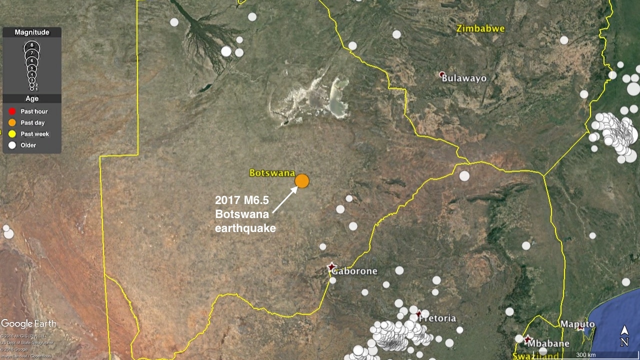 Recorded earthquakes in Botswana from the USGS catalogue
|
The largest earthquakes in southern Africa are concentrated in the
eastern countries of Tanzania, Malawi, and Mozambique, where the
continent is slowly pulling apart (rifting) in an east-west orientation.
This rifting forms the boundary between the Nubian and Somali plates
(part of the larger African plate) and results in normal faulting earthquakes. For example, the 2006 magnitude 7.0 Mozambique earthquake, which caused several fatalities, was a normal faulting earthquake, which ruptured the southern end of the East African Rift.
The April 2017 Botswana event is also classified as a normal faulting earthquake, yet its focal mechanism, which shows the orientation of extension, is approximately perpendicular to the East African rift. Therefore, a different geological structure, which may somehow be broadly related to the East African rift, may have been responsible for this earthquake. Earthquakes in Botswana are extremely rare. Given that this event has occurred over 1000 km from the nearest tectonic plate boundary, we call these types of events 'intraplate earthquakes'. It is likely that the rupture occurred partly due to the gradual transfer of push and pull stresses from the East African Rift toward the more stable part of the continent. Occasionally, this stress is released along pre-existing weaknesses in Earth's crust as earthquakes. It is fundamentally the same reason why quakes occasionally occur in other stable regions such as the United Kingdom and the midwestern states of North America. |
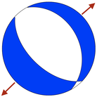
Top: Focal mechanism ('beach-ball') for the Botswana earthquake
indicating extension in anortheast-southwest direction. Bottom:
schematic block diagram showing sense of crustal movement during normal
faulting.
|
Recorded earthquakes in Botswana from the USGS catalogue
|
As with all earthquakes, there will be some aftershocks of this rupture.
From the nearest real-time seismometer station located ~270 km away
from the epicentre, smaller-sized aftershocks can be clearly seen
occurring in the hours ensuing after the mainshock.
Two aftershocks have been recorded by Germany's GEOFON monitoring system. One of these aftershocks had a magnitude of 4.6; the other magnitude 4.1. Based on Bath's aftershock law, it is plausible to expect aftershocks as large as magnitude 5.4. |
|
Possible complexity in the rupture
|
Early estimates of the earthquake's depth suggest that it occurred deep
within the continent (in the mid-lower crust). Therefore, there is
likely to be very little data available from possible surface ruptures.
When a large global earthquake occurs, the GEOSCOPE seismic observatory, based at IPGP in Paris, automatically calculate rupture 'source-time functions'. These graphs show how the amount of energy released by the earthquake changes during the rupture.
The GEOSCOPE solution (right) shows at least two distinct peaks in
energy release, possibly indicating that the earthquake was composed of
multiple, distinct ruptures.
This complex source time function can also be seen from the rare seismic waveforms from distant stations.
|
Multiple peaks in the rupture function indicate multiple fault ruptures. Source: Geoscope / IPGP (http://geoscope.ipgp.fr)
|
|
|
Displacement seismic waveforms from a recording station in Armenia. Some
complexity within the first 10 seconds of rupture (circled) can be
seen.
|
Stresses from Eastern Africa?
The central and western areas of Southern Africa are assumed to be
tectonically very stable. The geology of the region is typically
referred to as the 'Kaapvaal Craton'. Craton means a strong region of a continental tectonic plate that are typically stable for over a billion years.
The Kaapvaal Craton contains rocks that are 3.6 to 2.5 billion years
old. Large earthquakes in such stable tectonic environments occur very
rarely.
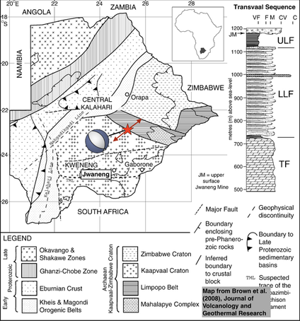
Comparing the location and mechanism of the Botswana earthquake with a regional geological map
reveals that the earthquake's epicentre may have occurred close to the
boundary between Kaapvaal rocks and those of the Limpopo Belt - a
distinct group of metamorphosed rocks with a slightly younger age of
~1.8 billion years old. This may simply just be a coincidence.
Furthermore, given the lack of nearby seismic stations, this exact
location may be uncertain. Nevertheless, it is worth considering what
implications such a relationship may have.
2017 Botswana earthquake epicentre (red star) together with focal
mechanism (blue beach ball) plotted on a regional geological map from
Brown et al. (2008). The red arrows indicate the direction of horizontal
extension during the earthquake.
Dr Eddie Dempsey
is a geologist from the University of Durham; he specialises in
analysing the structure of rocks that have been deformed deep within the
crust. He agrees that there may be an influence on the stresses and
resulting strains caused by rifting in East Africa. Stress may
eventually be released along old but relatively weak tectonic suture
zones to form occasional quakes like the Botswana event. Such old
cratonic rocks, however, are typically very layered (high seismic
anisotropy), which may complicate our analyses of this quake using
seismic waves.
Re-activation of an ancient tectonic boundary?
One research paper from the 1980s
studied the nature of the geological contact between Kaapvaal and
Limpopo further to the east in South Africa. Based on small changes in
gravity across the two groups of rocks, the study interpreted that this
geological contact demarcates an ancient (pre-Cambrian) plate boundary
between two colliding plates.
Is it therefore possible that the inherent weakness of this ancient,
billion-year-old plate boundary ruptured during the 2017 Botswana
earthquake? Whilst the craton as a whole stands strong, discrete weak
points could still be exploited by shifting tectonic stresses. Yet our
first estimates of the earthquake's location are somewhat uncertain;
therefore, much more research including on-the-ground field studies, as
well as analysis of satellite and geophysical data will be needed in the
next few months to better answer this question.
What we do know though is that earthquakes caused by intraplate
deformation will always be surprising to us; they have the potential to
produce very large and damaging earthquakes. Dr Susan Hough,
a seismologist at the United States Geological Survey says that stable
continental crust may occasionally produce earthquakes as large as
magnitude 7.5.
Everyone around the world, even those living in the most stable tectonic areas, should try to familiarise themselves with some simple procedures to follow if they experience shaking caused by an earthquake should the unexpected ever occur.
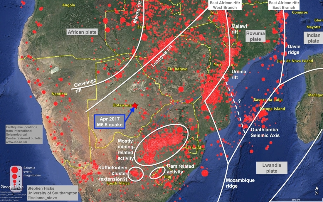
Update 1 (05/04): Interplay between tectonics and earthquake activity in southern Africa
I have made a quick map showing the distribution of ridges, rifts and
micro-plates in Southern Africa and how these relate to earthquake
activity in the region. Overall, the picture is very complicated but
shows the main network of structures that may have contributed to the
Botswana earthquake.

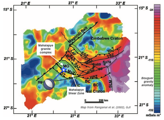
Update 2: Gravity sheds light on the possible fault(s) that ruptured
I have found a research paper from 2002 written by Ranganai et al. that
maps small changes in gravity over south-eastern Botswana to interpret
the location of ancient geological provinces and faults.
The April 2017 earthquake occurred in a highly deformed region separating the Kaapvaal Craton from the Zimbabwe Craton. The paper calls this region the Limpopo–Shashe Belt. This belt is composed of many northwest-southeast trending shear zones and reverse (thrust) faults that were formed as the Kaapvaal and Zimbabwe cratons slammed into each other billions of years ago (during the Archean eon). The authors speculate that this collision might have been similar to the same mountain building process that has resulted in the present-day Himalayan chain.
As the map shows below, the Mahalapye Shear Zone may be related to the fault that ruptured in April 2017. The orientation of the fault is parallel to the orientation of the focal mechanism. However, the rupture was extensional - not compressional like the mapped fault. Therefore, it is possible that the regional extensional rift tectonics in Southern Africa have reverse the sense of motion of these faults in a so-called stress inversion.
Gravity map of the southeastern Botswana region overlain with
interpreted fault locations and the 2017 Botswana earthquake. Gravity
map comes from Ranganai et al. (2002).
With the possible complexity of this earthquake that was suggested by
the early data, it is possible that more than one of these
closely-spaced faults ruptured during the magnitude 6.5 earthquake. More
detailed analysis will be needed to look at this possible scenario.
Further information
Januka
4/4/2017 15:51:49
Very nice summary Stephen!
Stephen Hicks
5/4/2017 08:06:40
Thank you for your comment!
Adele
4/4/2017 18:30:06
Excellent article. Thank you.
Stephen Hicks
5/4/2017 08:06:59
Thank you!
Stephen Hicks
5/4/2017 08:11:56
Thank you for reading!
Flip Nothling
4/4/2017 22:58:37
Thank you. Interesting article.
Could the earthquake be related to the Limpopo-Okavango rift which developed and stopped, with the break up of Gondwana? The earthquake appears to be to the south of the dykes but the extension seems to have the correct direction. (I am not a geologist.)
Could the earthquake be related to the Limpopo-Okavango rift which developed and stopped, with the break up of Gondwana? The earthquake appears to be to the south of the dykes but the extension seems to have the correct direction. (I am not a geologist.)
Stephen Hicks
5/4/2017 08:16:27
Interesting points - thanks for commenting. It's possible that
the earthquake might have been partly induced by Limpopo-Okavango. These
will be part of the scientific questions that need to be asked. You
certainly sound like a geologist!
Evan Proxie
5/4/2017 02:13:46
Please get deformation data. Maybe it will provide clues to what
exactly happened. This is very puzzling indeed. Possibly a new fault
line is being created or an entire tectonic plate is about to split.
Hidden super volcano maybe I am still looking at data
Stephen Hicks
5/4/2017 08:14:05
Interesting points - thanks for reading!
Penny Rees
5/4/2017 06:39:09
Most informative, thank you. Has anyone considered the fact that
evidence points to seismic activity resulting from fracking and that
fracking is now being g undertaken in Botswana
Stephen Hicks
5/4/2017 08:14:50
Interesting, but I don't think fracking could directly produce
such a large magnitude earthquake. Thanks for reading the post!
Paul Gray
5/4/2017 08:24:51
It is doubtful that fracking at this stage, has anything to do with this event, but it is most interesting.
There appears to be the geological faults, and additionally, areas of ancient magma outpouring, as well as extinct volcanoes and pipes. Some seem to relate to fault areas and others quite remote.
There appears to be the geological faults, and additionally, areas of ancient magma outpouring, as well as extinct volcanoes and pipes. Some seem to relate to fault areas and others quite remote.
5/4/2017 07:02:24
Yes as mid-west USA and the UK have only experienced these recently since the advent of Fracking?...
Certainly not a geologist but 2 and 2 are bound to add up pretty close to 4,..
Overlaying maps could assist,. http://www.survivalinternational.org/news/9762
Thanks for the insights Steven!
Certainly not a geologist but 2 and 2 are bound to add up pretty close to 4,..
Overlaying maps could assist,. http://www.survivalinternational.org/news/9762
Thanks for the insights Steven!
Stephen Hicks
5/4/2017 08:17:08
Interesting point, but I don't think fracking could directly
produce such a large magnitude earthquake. Thanks for reading my post.
Peter Bateman
6/4/2017 00:53:07
The fracking that was carried out in Botswana had been carried
out at a depth of 300 - 400 meters a few years ago in sedimentary and
therefore more plastic material. Fracture propagation is generally
horizontal in this type of material following along material with a
similar overburden pressure and similar material competency. This
tectonic quake has happened at a suggested depth of 30,000 meters in a
totally different material in a different location.
Penny Price
5/4/2017 08:19:05
Thank you for pulling together this very informative article so quickly. Appreciated.
Stephen Hicks
5/4/2017 19:54:56
Hi Penny, thanks for your comment.
Raf
5/4/2017 08:41:31
Very interesting and accurate summary. Bye from Italian geographers
Jerome Dyment
5/4/2017 08:45:49
The East African Rift does not separate the African and Indian
plates, as mistakenly written, but the Nubian and Somali plates which
together were earlier seen as a single African plate.
Stephen Hicks
5/4/2017 10:52:26
Hi Jerome
Many thanks for your comment and providing your expertise. Yes you were correct - I have now changed the text to reflect this.
Thanks again,
Stephen
Many thanks for your comment and providing your expertise. Yes you were correct - I have now changed the text to reflect this.
Thanks again,
Stephen
David
5/4/2017 10:17:54
Great article. I can't clearly make out from the map if the 12
hours earlier South African earthquake was on the same ancient plate
boundary.
Stephen Hicks
5/4/2017 10:55:31
Hi David
Thanks for your comment. I don't see any evidence that the Botswana quake was in any way related to the SA event. They are too far apart and the SA quake was much smaller.
Stephen
Thanks for your comment. I don't see any evidence that the Botswana quake was in any way related to the SA event. They are too far apart and the SA quake was much smaller.
Stephen
I'm reading this from Botswana, very interesting. But in
Moiyabana village Steve, where the quake initially started, it left a
rapture in the ground. Does that therefore mean there is high
possibility of yet another quake. Um saying this because the quake
happened yet again in the early hours of the morning today
Desmond Peach
5/4/2017 16:32:36
Thank you for a splendid explanation of the situation in Botswana
and surroundinding countries pertaining to the recent earth quake. The
weanessesi in th Craton layer and the effect of gravity.on the stress
plates was most interesting.
Stephen Hicks
5/4/2017 19:55:39
Desmond, thank you for commenting - I'm glad the post was understandable for you.
Abraham
5/4/2017 18:46:25
I thought the Tectonics are drifting towards North East in Africa. ..?Nice article and informative though.
Gaolatlhe
5/4/2017 19:25:57
Thanks Stephen for this eye opening article.
Gwandu
5/4/2017 19:28:17
Hi Steve thanks for the informative article. I am a geologists at
Botswana Geoscience Institute. I suggest we should wait for data from
all local seismic stations to accurately locate the epicentre. Then post
earthquake high res satellite images can be used and compared with
pre-earthquake images to check for any ground changes. Also both gravity
and magnetic survey can follow ti check any differences in terms of
subsurface structures.
Stephen Hicks
5/4/2017 19:57:19
Hi Gwandu.
Many thanks for taking the time to comment. This article was originally meant for a scientific audience but I'm glad it has stimulated some public interest. I will send you an email separately.
Many thanks,
Stephen
Many thanks for taking the time to comment. This article was originally meant for a scientific audience but I'm glad it has stimulated some public interest. I will send you an email separately.
Many thanks,
Stephen
Mark Green
5/4/2017 21:20:51
Hi
http://sphicks.weebly.com/blog-tectonic-debates/april-04th-2017
http://sphicks.weebly.com/blog-tectonic-debates/april-04th-2017
No comments :
Post a Comment