
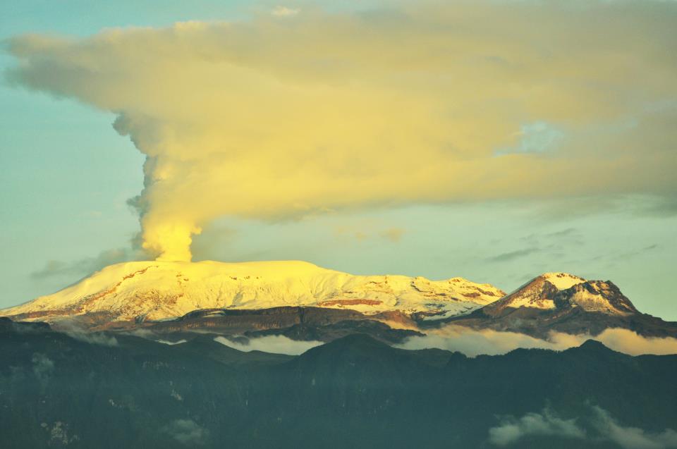
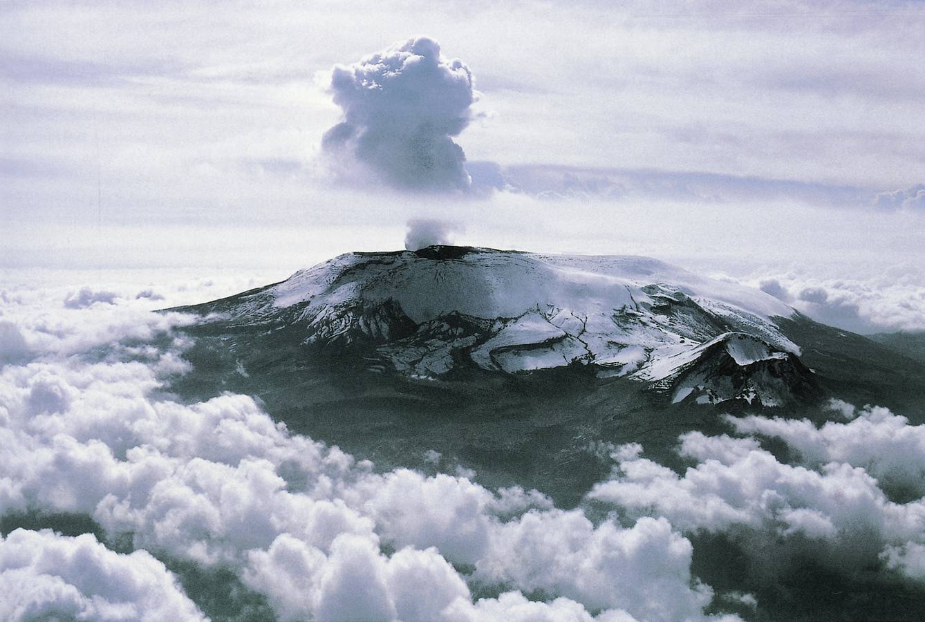
Nevado Del Ruiz , Colombia :
Weekly activity bulletin of the volcano Nevado del Ruiz, from 3 January to 9 January 2017The level of activity continues at activity level Yellow or (III): changes in the behavior of volcanic activity.
As regards the monitoring of the activity of the volcano Nevado del Ruiz, the Colombian Geological Survey reports that:
During the week, various monitoring parameters show that the volcano Nevado del Ruiz remains unstable.
Seismic activity related to the fracturing of volcanic rock under the volcano showed a slight increase in the number of earthquakes and seismic energy released compared to the previous week. This seismicity was located mainly in the South-South-West and Northeast zones, and to a lesser extent in the North, in the Southeast, the zones of the Arenas crater and towards the North-West sector of the volcano . The depths of the earthquakes varied between 0.9 and 6.7 km. The maximum magnitude recorded during the week was 1.8 ML (local magnitude), corresponding to an earthquake recorded on 6 January at 12:14 (local time), 3.3 km deep and located at 3 , 2 km south of the Arenas crater. It was highlighted the last week, the appearance of two episodes of seismic events of Drumbeat type, short-lived and low energy levels, which were recorded on 4 January at 13:30 / 14:00 (Local hour). This type of seismicity is related to the processes of ascension of domes * to the surface.
[*] Dome of lava: a mound of lava (molten rock) viscous placed on the point of emission of a volcano. The growth rate of domes can vary from a few hours to a few days, years, even hundreds of years, and volumes can reach tens of meters to several cubic kilometers.
Seismicity related to fluid dynamics in ducts of the volcanic structure was characterized by the appearance of earthquakes with different levels of energy, long period (LP) and very long period (VLP), pulses of tremors and earthquakes of multiple fluids. This type of seismicity also showed an increase in the number of earthquakes and the seismic energy released, in relation to the previous week. The earthquakes were mainly located in the Arenas crater, in the south-eastern sector of the volcano and to a lesser extent in the northern sector. Some of these seismic signals have been associated with the emission of gases and ash into the atmosphere, as confirmed by the cameras installed in the volcano region and reports from officials of the Natural Park of Los Nevados (Pnnn) . The recording of new seismic signals of this type with higher energy levels which may be associated with the emission of gas and ash is not excluded. It is important to remember that ash processes can occur over several days and sometimes several times a day without involving an individual report for each episode.
Volcanic deformation, measured from electronic inclinometers, Global Navigation Satellite Systems (GNSS) and satellite images to determine changes in inclination, position and shape of the volcano, continues to record in the last few months, inflation and intermittent inflation / deflation impulses, possibly linked to gas and ash emissions.
The volcano continues to emit significant amounts of water vapor and gases, including sulfur dioxide (SO2), as evidenced by the values obtained by the SCANDOAS stations installed in the volcanic zone and on the satellite image. In the tracking information provided by the Mirova site, he identified on 9 January, a thermal anomaly associated with low energy in the Arenas crater, with a value of 7.0 MW.
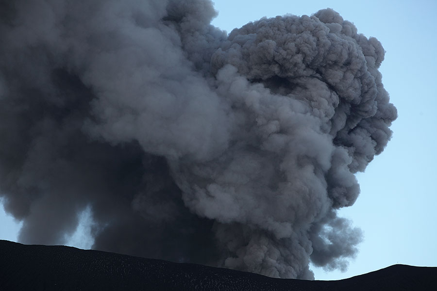
The column of gas, steam and ash from time to time reached a maximum height of 2500 m measured on the top of the volcano on 6 January. The direction of dispersal of the column was in line with the dominant wind regime in the area, which during the week fluctuated between Northeast and Southwest.
The volcano Nevado del Ruiz continues to activity level Amarillo.
Source : Ingeominas .
Images : Archives
Klyuchevskoy , Kamchatka :
56.06 N, 160.64 E;Elevation 15580 ft (4750 m)
Aviation Color Code is ORANGE
Moderate activity of the volcano continues. Satellite data by KVERT showed a thermal anomaly over the volcano; ash plume drifted about 158 km to the east from the volcano.

Volcanic Activity Summary:
Moderate explosive activity of the volcano summit crater continues. An ash plume raise up to 5 km a.s.l. and is drifting for about 30 km to the east from the volcano.
Activity of the volcano continues. Ash explosions up to 19,700-22,9606 ft (6-7 km) a.s.l. could occur at any time. Ongoing activity could affect low-flying aircraft.
Volcanic cloud height: 16400 ft (5000 m) AMSL
Time and method of ash plume/cloud height determination: 20170110/0135Z – Video data
Source : Kvert
Photo : Puma100 and Sergey Makurin
Popocatepetl , Mexico :
10 January 11:00 (17:00 GMT January 10)Over the past 24 hours, through the seismic recordings of the Popocatepetl volcano monitoring system, 35 low-intensity exhalations accompanied by water vapor, gas and small amounts of ash have been identified. In addition to eight explosions, the first four occurred yesterday at 11:07, 11:42, 15:26 and 18:59 and the other four today at 1:39, 6:33, 7:10 and 09:44.
In addition, there were recorded 60 minutes of tremor of very low amplitude, which occurred during intermittent segments with an average duration of 6 minutes.
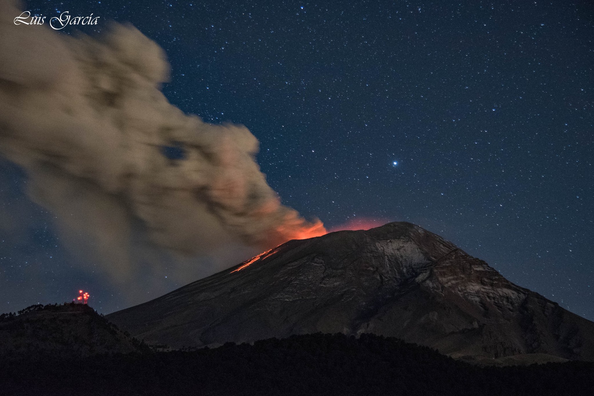
At dawn, a glimmer was observed in the area of the crater which increased during some episodes.
Finally, today two VT-type events that took place at 04:56 and 06:35, with respective magnitudes of M2.8 and M1.6 were recorded.
At the time of this report, a continuous emission of steam and gas is observed.
CENAPRED asked not to approach the volcano and in particular the crater.
The volcanic alert semaphore of Popocatepetl Volcano is located in Amarillo Phase 2
Source : Cenapred.
Photo : Luis Garcia
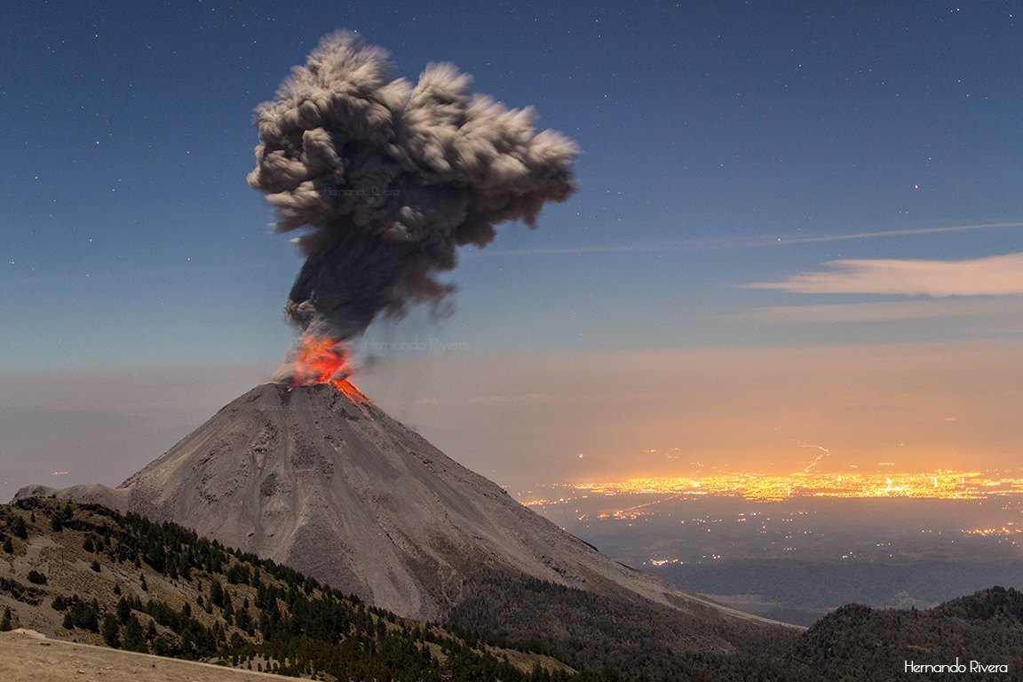
Colima , Mexico :
MEXICO The population surrounding the volcano Colima must be cautious, since this afternoon the volcano emitted an exhalation of 1800 meters.The Civil Protection and Fire Unit of the State of Jalisco reported on its Twitter account, @PCJalisco, the incident that occurred at 12:50 hours.
« # VolcánColima 12:50 exhalation vertical direction of 1,800 m, the exclusion perimeter in Jalisco is 7.5 km. No camp in the canyons ».
A few moments earlier, National Emergency Preparedness Coordinator Luis Felipe Puente announced that volcanic ash fell in three municipalities of Colima: Villa Alvarez, Cuauhtemoc and Comala.
In response, it is recommended that the population cover their mouth and nose, keep their eyes and throat clean, wear glasses, close windows, cover uncontaminated bodies of water, And stay inside the houses. The ash must be swept and not thrown into the sewer.
The airport suspended operations following the exhalations of the volcano Colima:
Colima airport suspended all activity after a reported explosion of the volcano, a situation that worsened after the exhalations.
Given the intense activity that began this afternoon on the Colima, the airport decided to cease its activity due to exhalations and ash falls. « # Airport Colima operations suspended at 20:00. We will continue to report this way. »
The airport is scheduled to resume tomorrow, 10 January at 11 am, and the public has been asked to follow the recommendations and be alert to the signs.
Source : diariodequeretaro.com , elsoldemexico.com
Photo : Hernando Rivera
Dukono , Indonesia :
Dukono Eruption Causes Two Districts Covered in Ash .11 JANUARY 2017. Dukono, which is located in North Halmahera, North Maluku, has increased its activity by spewing ash and vapor that reached 900 meters in height.
“Nevertheless, the status of the volcano is still on level II alert. Although the blast was pretty high this time,” says the head of Dukono monitoring post, Iwan Amat on Wednesday, January 11, 2017.
According to Iwan, the seismograph recorded Dukono’s high level activities had started since the last week. The volcano can be seen spitting volcanic ash to its Northeast.
According to Iwan, a number of regions in North Halmahera such as Galela and North Tobelo has been covered with volcanic ash. The public is urged the public not to approach its peak up to a 3 kilometer radius. “But the volcano’s activity is still safe for daily activities, so there’s no need to panic,” Iwan said.
Dukono is one of three volcanic mountains located at Halmahera Island. There are at least 23,000 residents living in four districts at the perimeter of Dukono. Dukono has been at level II Alert since June 15, 2008.
Source : TEMPO
Photo : photovolcanica.com
http://lechaudrondevulcain.com/blog/2017/01/11/january-11-2017-en-nevado-del-ruiz-klyuchevskoy-popocatepetl-colima-dukono/
No comments :
Post a Comment