
It’s an observational problem Dante describes as a “river of boiling blood and fire”.
In the poem, Hell is depicted as nine concentric circles of torment located within the Earth; it is the “realm … of those who have rejected spiritual values by yielding to bestial appetites or violence, or by perverting their human intellect to fraud or malice against their fellowmen.”
https://en.wikipedia.org/wiki/Inferno_(Dante)

In the first round of the seventh circle, the murderers, war-makers, plunderers and tyrants are immersed in Phlegethon, a river of boiling blood and fire.It’s an observational problem the Bible describes as a “lake which burneth with fire and brimstone”.
https://en.wikipedia.org/wiki/Inferno_(Dante)
“The fearful, and unbelieving … shall have their part in the lake which burneth with fire and brimstone.” — Revelation 21:8The problem being that hellishly hot conditions are surface features.
Skeptics Annotated Bible – What the Bible says about Burning People to Death
http://skepticsannotatedbible.com/says_about/burning.html
According to the Earth Scientists about 75% of the Earth’s surface has [at one time or another] experienced these hellishly hot conditions.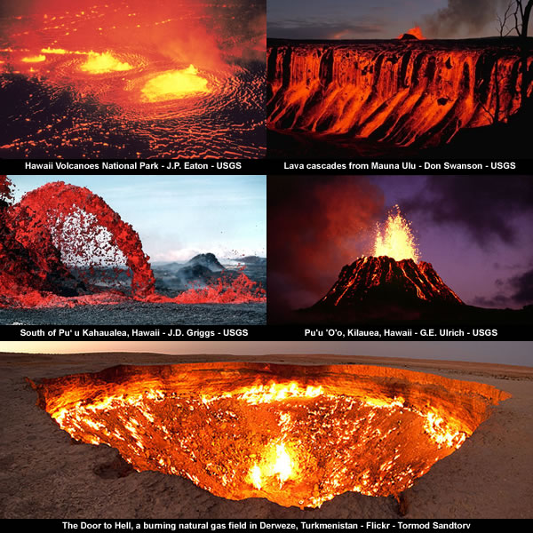

Igneous rock is formed through the cooling and solidification of magma or lava.These hellishly hot conditions are also found lurking beneath the surface.
…
Igneous rocks form about 15% of the Earth’s current land surface.
Most of the Earth’s oceanic crust is made of igneous rock.
https://en.wikipedia.org/wiki/Igneous_rock
Saline water covers approximately 360,000,000 km2 (140,000,000 sq mi) and is customarily divided into several principal oceans and smaller seas, with the ocean covering approximately 71% of Earth’s surface and 90% of the Earth’s biosphere.
https://en.wikipedia.org/wiki/Ocean
Which leaves the independent observer to ponder:
The Iceland Deep Drilling Project, while drilling several 5,000m holes in an attempt to harness the heat in the volcanic bedrock below the surface of Iceland, struck a pocket of magma at 2,100m in 2009.
https://en.wikipedia.org/wiki/Magma
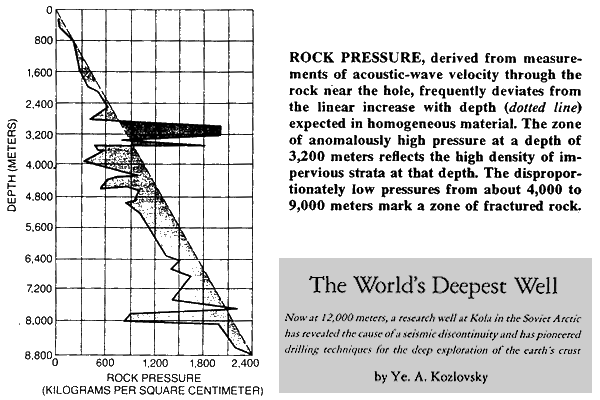
The Lone Star Producing Co. 1–27 Bertha Rogers hole or well was an oil-exploratory hole drilled in Washita County, Oklahoma in 1974, and was formerly the world’s deepest hole until in 1979 surpassed by the Kola Superdeep Borehole, dug by the USSR.
It took Lone Star a little over a year and a half to reach 31,441 feet (9,583 m), a depth of almost six miles. During drilling, the well encountered enormous pressure – almost 25,000 psi (172,369 kPa).
No commercial hydrocarbons were found before drilling hit a molten sulfur deposit (which melted the drill bit).
https://en.wikipedia.org/wiki/Bertha_Rogers

Do these hellishly hot conditions really originate deep down in the Earth?
One the one hand:
The Earth Scientists claim magma is “upwelling” from “3,000 km deep in the Earth” and that temperatures get progressively higher towards the centre of the Earth.
Volcanism away from plate boundaries has also been explained as mantle plumes.One the other hand:
These so-called “hotspots“, for example Hawaii, are postulated to arise from upwelling diapirs with magma from the core–mantle boundary, 3,000 km deep in the Earth.
https://en.wikipedia.org/wiki/Volcano
The temperature at the inner core boundary is approximately 5700 K (5400 °C).
https://en.wikipedia.org/wiki/Inner_core
A report published in the journal Science concludes that the melting temperature of iron at the inner core boundary is 6230 ± 500 K, roughly 1000 K higher than previous estimates.
https://en.wikipedia.org/wiki/Inner_core
Observational science has only scratched the surface of the Earth down to 12,262 metres.
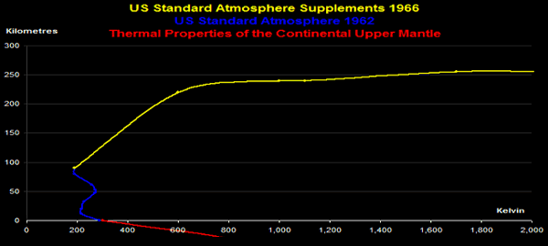
From these limited observations the Earth Scientists have arrived at an average geothermal gradient of “about 25 °C per km of depth”.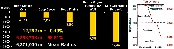

Geothermal gradient is the rate of increasing temperature with respect to increasing depth in the Earth’s interior.Based purely upon this mainstream temperature gradient the centre of the Earth is calculated to be [as a first approximation] 159,275 °C i.e. 25 °C/km for 6,371 km.
Away from tectonic plate boundaries, it is about 25 °C per km of depth (1 °F per 70 feet of depth) near the surface in most of the world.
https://en.wikipedia.org/wiki/Geothermal_gradient
The Kola Superdeep Borehole is the result of a scientific drilling project of the Soviet Union in the Pechengsky District, on the Kola Peninsula.
…
The deepest, SG-3, reached 12,262 metres (40,230 ft) in 1989 and still is the deepest artificial point on Earth.
https://en.wikipedia.org/wiki/Kola_Superdeep_Borehole

This is over 150,000 °C hotter than the temperatures promoted by the Earth Scientists.
This is over 150,000 °C hotter than the surface of the Sun promoted by the Space Cadets.
The Sun is a G2V star, with G2 indicating its surface temperature of approximately 5,778 K (5,505 °C, 9,941 °F)Either way:
https://en.wikipedia.org/wiki/Sun
There is a strong case for arguing that a highly [internally] pressurised Earth would have a tendency to pop like a balloon if it was actually punctured down to a depth of [about] 3,000 kilometres [as claimed by the Earth Scientists].
Another confounding issue for the medieval mysticism of the Earth Scientists is that the average geothermal gradient of “about 25 °C per km of depth” means the hellishly hot conditions associated with magma occur at a depth of [only] between 24 and 64 kilometres.


Magma is a complex high-temperature fluid substance.In other words:
Temperatures of most magmas are in the range 700 °C to 1300 °C (or 1300 °F to 2400 °F), but very rare carbonatite magmas may be as cool as 600 °C, and komatiite magmas may have been as hot as 1600 °C.
Most magmas are silicate mixtures.
https://en.wikipedia.org/wiki/Magma
The observational data indicates all of the hellishly hot conditions encountered on the surface [and immediate sub-surface] are associated with the uppermost 1% of the Earth.
Putting it more bluntly:
Our insights into the interior of the Earth are limited [at best] to a depth of 64 kilometres and any deeper knowledge claimed by the Earth Scientists is pure medieval mysticism mixed with a lot of hellishly hot air.
The oceanic crust is 5 km (3 mi) to 10 km (6 mi) thick and is composed primarily of basalt, diabase, and gabbro.Furthermore, the medieval mysticism of the Earth Scientists encounters serious problems long before they reach a depth of 64 kilometres.
The continental crust is typically from 30 km (20 mi) to 50 km (30 mi) thick and is mostly composed of slightly less dense rocks than those of the oceanic crust.
https://en.wikipedia.org/wiki/Crust_(geology)
The Mohorovičić discontinuity is 5 to 10 kilometres (3–6 mi) below the ocean floor, and 20 to 90 kilometres (10–60 mi), with an average of 35 kilometres (22 mi), beneath typical continental crusts.
https://en.wikipedia.org/wiki/Mohorovi%C4%8Di%C4%87_discontinuity
The main problem being that the average geothermal gradient of “about 25 °C per km of depth” claimed by the Earth Scientists is very rarely observed.
For example, in the state of Rio de Janeiro the reported gradients range from 14 to 33 ºC/km.
The results obtained indicate that geothermal gradient values are in the ranges of 14 to 26ºC/km in Precambrian metamorphic terrain and 19 to 33ºC/km in areas of Phanerozoic sedimentary basins.The diversity of reported geothermal gradients suggests:
Geothermal Gradient and Heat Flow in the State Of Rio de Janeiro
Antonio Jorge de Lima Gomes and Valiya Mannathal Hamza
Revista Brasileira de Geofísica – Vol 23 No 4 – São Paulo – Oct/Dec 2005
http://www.scielo.br/scielo.php?script=sci_arttext&pid=S0102-261X2005000400001

1) The geothermal gradient does not originate from a common deep source.
2) The heat source is localised and is determined by local geological activity.
3) The resulting geothermal gradient is determined by the conductivity of the local formation[s].
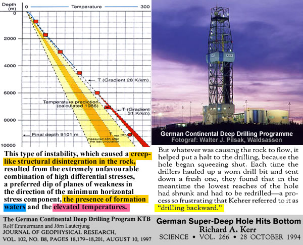
These suggestions are underlined by the German Continental Deep Drilling Programme which encountered flowing rock at a depth of [only] 9 kilometres.
But whatever was causing the rock to flow, it helped put a halt to the drilling, because the hole began squeezing shut.In other words:
Each time the drillers hauled up a worn drill bit and sent down a fresh one, they found that in the meantime the lowest reaches of the hole had shrunk and had to be redrilled – a process so frustrating that Kehrer referred to it as “drilling backward.”
German Super-Deep Hole Hits Bottom
Richard A. Kerr – Science – Vol 266 – 28 Oct 1994
http://science.sciencemag.org/content/266/5185/545
The German Continental Deep Drilling Programme (in German: Kontinentales Tiefbohrprogramm der Bundesrepublik Deutschland), abbreviated as the KTB borehole, was a scientific drilling project carried out from 1987 to 1995 near Windischeschenbach, Bavaria.
The main superdeep borehole reached a depth of 9,101 metres in the Earth’s continental crust.
https://en.wikipedia.org/wiki/German_Continental_Deep_Drilling_Programme

Rock formations begin to behave like a viscous fluid long before the 50 kilometre depth determined by the medieval mysticism of the Earth Scientists.
Earthquakes at shallow depths are a result of stick-slip faulting; however, below about 50 km (31 mi) the hot, high pressure conditions ought to inhibit further seismicity.Perhaps it’s time to look for a localised heat source that’s associated with geological activity…
The mantle is considered to be viscous and incapable of brittle faulting
https://en.wikipedia.org/wiki/Mantle_(geology)
https://malagabay.wordpress.com/2017/06/22/flipping-geology-walking-on-sunshine/
No comments :
Post a Comment