
Readings taken at the North Canterbury town of Waiau during the November event proved a new record for vertical ground acceleration, reaching 3g, or 30 times the force an airliner passenger feels at take-off.
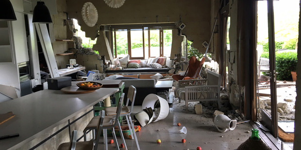
Just-published research has detailed the incredible ground motion generated by the midnight quake, which triggered a tsunami and thousands of landslides, caused billions of dollars of damage, shifted the South Island and left two people dead.
While the November 14 quake erupted near the small North Canterbury town of Culverden, scientists say it was Waiau, about 22 kilometres away, that bore a New Zealand record for the most severe upward ground shaking.
One instrument at Waiau, since confirmed to have been functioning correctly, showed a maximum vertical acceleration of about 3g, eclipsing the previous national record of 2.2g produced by the February 2011 Christchurch Earthquake.
By comparison, passengers on airliners feel accelerations of around 0.1g on take-off, while someone in a car speeding up from 0km/h to around 100km/h in 10 seconds would experience 0.25g.
GNS seismologist Dr Anna Kaiser, the lead author of the new study, said someone riding a rollercoaster would feel forces greater than 1g; but they'd of course be strapped in.
Waiau School principal Mary Kimber said the power of the quake, which shook bricks from her home and ripped shelves off their bolts, was terrifying.
"I was actually cowering on the floor ... people say, why didn't you get under the doorway? Well, you couldn't move, it was just too strong."
Waiau Pub co-owner Lindsay Collins, who was in Christchurch for all of the major Canterbury quakes, said the shake was the most frightening he'd experienced.
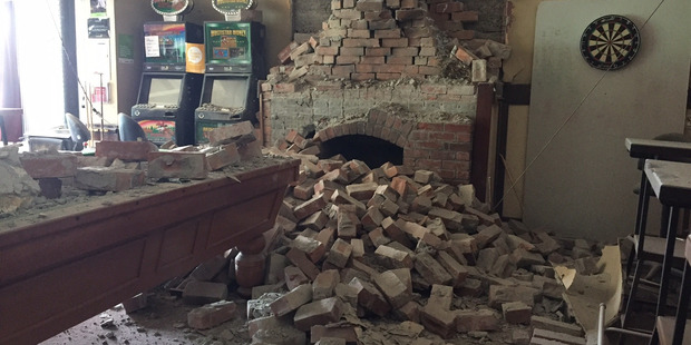
"I managed to get out of the bedroom after falling over bits and pieces, I got my son out of his room, and we stood there for a good minute while the shaking was going on ... it felt like a train."
Elsewhere, PGA readings of more than 1g, and therefore higher than that due to gravity, were recorded more than 100km away at Kekerengu (up to 1.2g) and Ward (up to 1.3g).
The total energy produced by the entire quake was equivalent to that of 400 atom bombs, or enough to power every South Island home for a year.
Its 8000 kiloton TNT equivalent was around 11 times more than the 2010 7.1 Darfield Earthquake and about 60 times more than the twin quakes that shook Marlborough in 2013.
Science of the quake
Kaiser said the Waiau recording had some "very unusual characteristics", notably very strong upward acceleration compared with downward acceleration."This suggests there could be a trampoline effect going on, where the instrument is thrown upwards with very strong acceleration and then it descends before encountering another very strong push which sends it sharply back up again."
It was unclear what had caused it, but it was possible that soft soil near the surface interacting with stiffer material beneath may have worsened the shaking.
The Ward and Kekerengu Valley instruments were located close to the Kekerengu and Needles faults, where massive amounts of energy were released during the rupture.
Kaiser said the ground motion at these instruments, and also in Wellington, may also have been increased by the "directivity effect", created when seismic energy was being released at the same time as a rupture was unzipping along a fault.
"This means if the rupture is coming towards you, energy can be stacked together and you might experience stronger shaking than if the rupture is moving away from you in the other direction, even if you are the same distance from the fault."
But trying to pinpoint different ground accelerations across the South Island was a complicated task, because of the many different faults and soil types involved.
While PGA rates were a good measure of how sharp the shaking was, there were other important factors to consider, such as the permanent movement of land, parts of the South Island were shunted 5 metres closer to the North Island, along with the duration of ground shaking and the strength of rolling-type motions, which could be enhanced by the presence of deep or soft soils.
Researchers toil in quake's wake
Trying to unravel the mysteries of what was the most complex earthquake ever recorded remains a big job for GNS Science.Around 45 staff at the institute are still spending nearly half their time studying the quake, as part of national and international efforts.
As the quake was one of the best-recorded event in history, yielding a rich array of data, fresh insights across all facets of earthquake science will likely be flowing in for years.
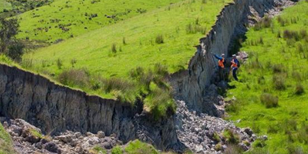
It collectively encompasses the Kekerengu Fault, the Jordan Thrust, the Upper Kowhai Fault, and the Needles Fault.
One point of interest is the Clarence Valley where five faults intersect: Investigations into this quintuple intersection area will improve the understanding of how multiple faults interact in three dimensions during a single earthquake.
With science now suggesting that these complex ruptures are more common in large earthquakes in New Zealand than previously thought, improving the understanding of how these ruptures occur will help New Zealand be better prepared for future events.
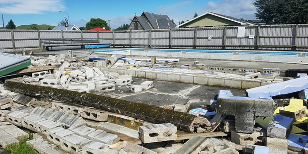
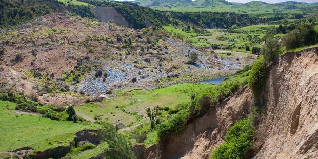
Mapping and analysing the thousands of landslides the quake caused has also been a priority for the scientific effort.
Landslides have blocked main roads, dammed water ways and damaged large areas of land and critical infrastructure throughout the impacted area of the upper South Island.
Most occurred in either the weak, young mudstones and sandstones or in the harder, older greywacke rocks.
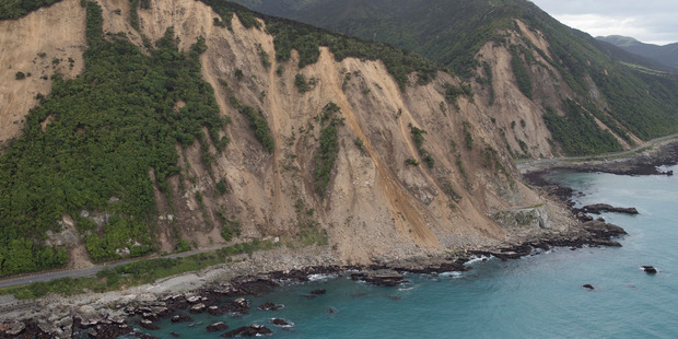
Further, the earthquake had loosened and mobilised debris, which could be more susceptible to failure in the future and affect river catchments for some time.
Scientists say the landslides appear to cluster around areas of observed fault rupture, rather than close to the earthquake epicentre as normally expected, making the interaction between landslides and fault ruptures an important area of research in the future.
GNS soil mechanics scientist Dr Jon Carey said a range of technology was being used to study the landslides and attempt to measure their stability.
This included satellite imagery, aerial photography, laser scanning and drones equipped with technology that could reveal structural changes in landslides.
"What we are trying to do is collate as much information as possible to create a really big database, and compare this earthquake to previous and future ones," Carey said.
With around 15,000 quakes since the November 14 event, scientists have statistically forecast a 10 per cent probability of an aftershock of more than 7.0 in the next year, a 68 per cent probability of a 6.0-6.9 quake, and a 99 per cent probability of five to 26 quakes ranging between 5.0 and 5.9.
New study to shed light on Auckland quake risk
Meanwhile, a new study is centring on known and potential faults in an area close to New Zealand's largest city.
In a newly-funded project, an international team of scientists led by the University of Auckland's Dr Jennifer Eccles is working to understand the dynamics of the slow-moving Hauraki Rift.
The geological structure contains the active Kerepehi Fault, which runs between Matamata and north towards Waiheke Island, and lies only 30km east of Auckland and Hamilton.
"The Hauraki Rift is not as active as areas around Canterbury and the north of the South Island that have suffered recent large earthquakes," Eccles said.
"However, the Christchurch earthquakes in particular highlighted the need to research and better understand slower moving geological structures that have the potential to pose a significant natural hazard risk to high population areas and infrastructure."
 Yet the rift remained poorly understood, and there had been no significant scientific research into the seismic area in decades.
The team would be specifically working to understand the geology and activity of the Kerepehi Fault, recently revealed to consist of a belt of many faults, in a wide zone of segments that could potentially experience a large quake every 1000 years.
Eccles and her colleagues would also try to identify blind faults or activity on mapped faults currently deemed inactive across the Hauraki Plains and Auckland city.
The team are using regional GPS measurements to monitor how the region is stretching through time and are building a model of the ground to understand its properties and composition from using reflected seismic waves.
"These are waves of vibrational energy that travel through the Earth's layers and interact with the subsurface," Eccles explained.
"These vibrations are recorded and measured at various locations and depths to build an understanding of faults at depth including possible fault lines previously undetected."
"These projects will improve the scientific community's knowledge of the Kerepehi Fault and the wider Hauraki Rift and what seismic movement is taking place within this area.
"They also contribute to building a bigger picture of seismic activity in New Zealand and helps our communities become more prepared for and resilient to a natural disaster event."
A 2013 GNS report into potential impacts on Auckland looked at a trio of scenario earthquake sources: two were nearby active faults, the Wairoa North and the offshore segment of the Kerepehi fault, and the third was the more distant Kermadec Subduction Zone.
This was equated to the 526,000 buildings in the region, valued at $309 billion and housing 1.4 million people.
In the first two scenarios, large quakes could cause up to 53 and up to 26 deaths in the region respectively, along with $1.9b and $1b in damage.
The new study has received a $70,000 grant from the Earthquake Commission's Biennial Grants Programme and $75,000 as part of the EQC University Post-Graduate Grant Programme.
http://www.nzherald.co.nz/nz/news/article.cfm?c_id=1&objectid=11835085
No comments :
Post a Comment