This is old, from the old earthquake, but I thought it is interesting and share it with you.
- Title Kathmandu fringes
- Released 29/04/2015 4:54 pm
- Copyright Contains Copernicus data (2015)/R. Grandin/IPGP/CNRS
- Description
Sentinel-1A interferogram over Kathmandu, Nepal, showing deformation
induced by the 25 April 2015 earthquake. East–west ‘fringes’ cross the
city, with each coloured fringe corresponding to 2.8 cm of ground
displacement (both uplift and subsidence). The interferogram combines
two Sentinel-1A images from 17 and 29 April 2015.
Correspondingly, for NEPAL as a whole, see below:
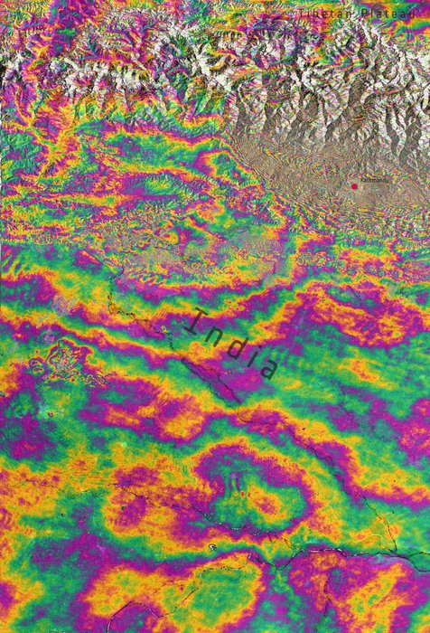
- Title Nepal earthquake deformation
- Released 29/04/2015 5:16 pm
- Copyright Contains Copernicus data (2015)/ESA/DLR Microwaves and Radar Institute/GFZ/e-GEOS/INGV–ESA SEOM INSARAP study
- Description
Interferogram over Kathmandu, Nepal, generated from two Sentinel-1A
scans on 17 and 29 April 2015 – before and after the 25 April
earthquake. Each ‘fringe’ of colour represents about 3 cm of
deformation. The large amount of fringes indicates a large deformation
pattern with ground motions of 1 m or more.
- Title Nepal earthquake
- Released 29/04/2015 4:50 pm
- Copyright Contains Copernicus data (2015)/ESA/Norut/PPO.labs/COMET–ESA SEOM INSARAP study
- Description
Combining two Sentinel-1A radar scans from 17 and 29 April 2015, this
interferogram shows changes on the ground that occurred during the 25
April earthquake that struck Nepal. An overall area of 120x100 km has
moved – half of that uplifted and the other half, north of Kathmandu
subsided. Vertical accuracy is a few cm.
http://www.esa.int/spaceinimages/Images/2015/04/Nepal_earthquake_deformation


No comments :
Post a Comment